Pages 74-76
A History of the County of Lancaster: Volume 8. Originally published by Victoria County History, London, 1914.
This free content was digitised by double rekeying. All rights reserved.
In this section
QUERNMORE
Quernemor, Quernemore, 1228. The local pronunciation is Wharmer.
This hilly district was part of the forest of the lords of Lancaster. The northern portion contains the well-wooded Quernmore Park; going east from Lancaster the ground rises till 500 ft. above sea level is reached at a spot affording a fine view over Morecambe Bay, and then descends steeply towards the source of the Conder. This stream flows south, and most of the township drains into it; but north of its source the ground falls away to the Lune, being watered by small brooks, of which Escowbeck is the chief. Still further east of the Conder source the surface rises quickly till 540 ft. is attained. The southern part of the township lies on the western slopes of Clougha Pike, the heights ranging from 1,500 ft. above sea level on the east to 132 ft. beside the Conder, which here forms the boundary. The area measures 6,789½ acres, (fn. 1) but the population in 1901 was no more than 606, including 77 belonging to the old township of Bulk.
One road from Lancaster to Caton and Hornby goes along the south bank of the Lune by the beautiful Crook of Lune, where the river makes a sharp turn south and then north between steep treeclad banks; overlooking it are Scarthwaite and Escowbeck Hall. Another road goes from the east side of Lancaster over the hill and then north-east down the valley to Caton, with Quernmore Park on the western side. This road is joined by another coming north from Garstang. Yet another road, that from Lancaster into Wyresdale, crosses the southern part of the township in a south-east direction. The Midland Railway Company's line from Lancaster to Hellifield runs through the northern edge, by the Lune, and has a station called Halton.
Roman pottery works have been discovered.
In 1625 a meeting of recusants was held at Quernmore, ostensibly for hunting, but probably to consult as to some petition for relief. The chief justice found nothing to proceed upon. (fn. 2)
The township is governed by a parish council. Its bounds were extended in 1900 to include the part of Bulk not then taken into the borough of Lancaster. (fn. 3)
The land is mostly in pasture; the soil is light, with clay subsoil.
The pipe line of the Thirlmere-Manchester water supply passes through the township.
Forest
In 1066 the northern part of the later QUERNMORE was as Hotun held by Earl Tostig as a member of his fee of Halton; it was assessed as two plough-lands. (fn. 4) The southern part may have been considered a dependency of Lancaster in the same lordship. Afterwards the whole was included in the forest, (fn. 5) but the burgesses of Lancaster had certain rights of common. (fn. 6) Earl Edmund in 1278 inclosed Quernmore Park, (fn. 7) which thus became to some extent a separate estate.
Accounts of William de Hornby, master forester in 1314, have been printed. The receipts were for the agistment of cattle, sale of dead wood, &c.; millstones were sold for 6s. The expenditure was for wages, repairs to the paling of the park and the stone wall there, cutting down branches for the deer in winter and so forth. (fn. 8)
In 1346 a customary due called ' boon silver' was payable, amounting to 7½d. (fn. 9) At the same time the herbage of the Park produced £13 6s. 8d. and that of the rest of Quernmore £6; millstones yielded ls. (fn. 10)
During the year ending Michaelmas 1441 two swainmotes were held for Quernmore and two for Wyresdale; various small sums were received from perquisites of court, fishery of the Wyre from Damas Gill to the head of the river, and turves. Nothing was received for slate stones, honey and wax. The herbage of Quernmore produced 45s., the rent of Scarthwaite was 13s. 4d., and of Hollinhead 53s. 4d. The wages of Thomas Urswick, master forester, and the building of a house, thatched with rushes, brought the net receipts down to 19s. 11d. Thomas Harrington was parker of Quernmore Park, and his payment amounted to £4 10s., chiefly derived from letting the herbage. (fn. 11) Swainmote courts were kept much later than this, (fn. 12) and deer might be hunted there as late as the 16th century. (fn. 13)
Owing to its peculiar tenure the township is seldom mentioned in the records. (fn. 14) William Singleton of Bank Hall in Broughton in 1573 held a tenement in Quernmore of the queen as of her honour of Torrington in Devonshire. (fn. 15) Various grants were made from time to time, (fn. 16) and in 1630 QUERNMORE PARK was sold by the Crown. (fn. 17) It became the property of Sir Thomas Preston of Furness, and was in 1681 in danger of confiscation, like other of his estates, because it was suspected he had given it to the Jesuits. (fn. 18) It went by marriage to Hugh Lord Clifford of Chudleigh (fn. 19) and descended in his family till 1794, (fn. 20) when it was purchased by Charles Gibson of Preston, who died in 1823. His son and successor of the same name died in 1832, (fn. 21) and ten years later the park was purchased by William Garnett of Lark Hill, Salford, (fn. 22) who has been noticed in the account of Bleasdale. Quernmore Park descended in the same way to his grandson, Mr. William Garnett.

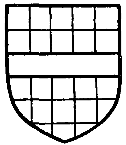
Clifford, Lord Clifford of Chudleigh. Chequy or and azure a fesse gules.
William Rippon in 1631 compounded for refusing knighthood. (fn. 23) In 1717 Mary Walmesley of Park Hall in Quernmore, widow, registered her estate as a 'Papist.' (fn. 24)

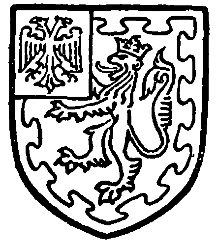
Garnett of Quernmore. Gules a lion rampant argent ducally crowned within a bordure nebuly or, in a canton of the last a double-headed eagle sable.
An Inclosure Act was passed in 1811, (fn. 25) and the award, dated 1817, is kept at Lancaster Castle. (fn. 26)
In connexion with the Church of England the first St. Peter's was built in 1834. and was replaced by the present church in 1860. The incumbents, who are styled rectors, are presented by the vicar of Lancaster. (fn. 27)
The other places of worship are for the Wesleyan Methodists and the Society of Friends. (fn. 28)
While the Prestons held the Park there was a resident priest to minister to the Roman Catholics of Quernmore and Bulk. (fn. 29)


