

Pages 296-299
A History of the County of Oxford: Volume 12, Wootton Hundred (South) Including Woodstock. Originally published by Victoria County History, London, 1990.
This free content was digitised by double rekeying. All rights reserved.
Introduction
Wilcote, comprising only 319 a. (128 ha.), was, until its absorption into the civil parish of North Leigh in 1932, among the smallest rural parishes in England. (fn. 49) It lies 4 miles (6.4 km.) south by east of Charlbury, and 5 miles (8 km.) north by east of Witney, for long its market and social centre. (fn. 50) Wilcote was from the Middle Ages and possibly earlier a hamlet of Cogges, with which it was usually combined for purposes of taxation and poor relief into the 19th century (fn. 51); the two places were returned together in census reports until 1831. (fn. 52) From the mid 19th century, however, until 1932 Wilcote was regarded as a separate parish for civil purposes, and it has remained a distinct ecclesiastical parish. (fn. 53)
The parish was elongated in shape, tapering towards the southern end but with westwards projections at the north-west and south-west corners. It has been suggested that the north-west projection derived from the incorporation into Wilcote of the site of a Romano-British settlement. (fn. 54) It has further been suggested that the boundary in the south-west skirted an 8th-century burial ground near the boundary with North Leigh. (fn. 55) the projection seems excessive for such a purpose alone, and the boundary appears rather to have followed the line of Burford Way, a road that formerly ran from North Leigh through Wilcote and Minster Lovell. The stretch of road, c. 300 m., marking the boundary has been obliterated by ploughing. The parish boundary is rarely marked by existing roads and watercourses but often by substantial hedges, ditches, and embankments, and by thick belts of woodland on the north and west where it is also the boundary of Wootton hundred. The boundary on the east follows a short stretch of the road from North Leigh to Finstock and on the south North Leigh Lane, which joins Burford Way at the south-west corner. The line of the Roman Akeman Street, discernible traversing the parish c. 100 m. inside the northern boundary, is completely ignored; only a few parish boundaries in the area made use of it. (fn. 56)
Wilcote's western boundary is apparently described in charters of 969 and 1044 for Witney manor. (fn. 57) The features mentioned are not certainly identifiable but seem to begin in the parish's north-west corner, called Wicham, a name associated with former Romano-British vicus settlements. The perambulation followed the edge of a wood to Ofling acre and the old or sheep way, presumably the Wilcote-Hailey road. The next marker, Cycgan stone, may have been near the north-west tip of Holly Grove, along whose western edge, described as a green way, the perambulation proceeded to Yccenes feld, meaning open land by the Itchen, the otherwise nameless stream that traverses the southern end of the parish. The route seems then to have followed hedgerows to Madley brook in North Leigh parish. The perambulations of Wychwood forest in 1298 and 1300 seem to have passed along part of Wilcote's eastern boundary and possibly its southern also, but the features mentioned are not clear. (fn. 58) The perambulations then probably retraced the line of the charter boundaries along the parish's western side; the places recorded, Sigardesthorn and Nethergate, have not been identified. (fn. 59)
Wilcote village stands on a hilltop towards the north-east end of the parish at a height of 140 m., the land falling to its lowest point of 105 m. in the shallow valley that cuts across the southern end of the parish. Much of the southern half of the parish lies on limestone of the Great Oolite series, overlain on the higher ground in the north by an extensive bed of forest marble, above which are smaller outcrops of cornbrash and Oxford clay surmounted by an island of unbedded glacial drift upon which stand the church, manor house, and Wilcote Grange. (fn. 60) The water table is unusually close to the surface, and the soil, except on the southern slope, where it drains more freely, is prone to waterlogging, even on the high ground. There are several ponds near the church, and in the centre of the parish an underground brook and series of springs feed the former manorial fishponds, recorded in 1581; (fn. 61) two ponds remain, repaired in 1986. (fn. 62) The valley at the southern end of the parish was apparently created by a former meander of the river Windrush. (fn. 63) The stonebrash on either side of the stream has traditionally provided good arable crops, although the ground just south of the stream becomes boggy in wet weather. The remaining land has been used both for arable crops and for grass, the former more usually grown in the fields north of the Hailey road, the latter in the fields adjacent to Wilcote Manor and Wilcote Grange; traces of ridge and furrow east of Wilcote Grange, however, indicate that even the heavy Oxford clay was at one time put under the plough. Almost a quarter of the parish remains woodland, most of it growing densely in the west of the parish and along the northern boundary. Further planting of broad-leaved woodland, on the manor estate, was under way in 1987. Wilcote lay within the royal forest of Wychwood until excluded at the time of the perambulations of the late 13th century.
The only metalled road to pass through the parish is that running from Ashford bridge in North Leigh to Hailey. West of Wilcote church the road forms a hollow way. In 1850 the road forked as it left the parish on the west, a branch running to Ramsden; that branch survives as a footpath. Another way, since ploughed out, ran south along the western edge of Holly Grove (fn. 64) to meet the broad path, in parts a hollow way, from Wilcote Grange through Holly Grove towards Witney. The avenue of pollarded ash trees that runs south from Wilcote Grange to Lady well, a spring north-west of the fishponds, marks the line of a way that in the earlier 19th century continued to Burford Way. That line was partly ploughed over by 1850, (fn. 65) but later restored as a footpath. The crossroads east of Wilcote Manor gives access to Finstock, Woodstock, and North Leigh.
Flint implements of uncertain period have been found in the field north of Wilcote Manor. The earliest evidence of settlement in the parish is a Roman villa in the south-east corner of the parish, and Romano-British coins, pottery, and stoneware unearthed along the line of Akeman Street. The quantity and extent of finds there have been interpreted as the remains of a settlement larger than a single house, a possibility strengthened by the use in boundary charters of the Anglo-Saxon place name Wicham. (fn. 66) It was probably that site to which Thomas Hearne referred in 1724 when mentioning the discovery of Roman coins and 'some other Roman antiquity'. (fn. 67) The villa is commonly known as Shakenoak from Shakenoak Farm, c. 500 m. to the north-west. (fn. 68) Building began late in the 1st century A.D. on a site just north of the stream. While never matching the great villa at North Leigh in scale and prosperity, with painted plaster, for instance, instead of mosaics, the villa was rebuilt and expanded more than once. In the mid 3rd century the focus was transferred to a small though well appointed house south of the stream, possibly because of the villa's absorption by its wealthier neighbour. Military belt fittings and Germanic artefacts of the early 5th century have prompted the suggestion that mercenary troops, hired to protect the North Leigh villa, may have been housed at Wilcote. Despite claims for continuity of occupation at Wilcote into the 8th century, it seems more likely that the site was temporarily abandoned after c. 420, (fn. 69) about the time that North Leigh was deserted. (fn. 70) The Wilcote site was resettled in the 7th century and not finally deserted until the mid 8th, following the burial there of several men, possibly the victims of a battle. The later period of settlement has left evidence of iron smelting and wool working, and of a mixed agricultural economy based on arable farming and the keeping of cattle, sheep, and pigs. (fn. 71) Settlement thereafter probably withdrew from valuable arable land, perhaps concentrating on the hilltop site of the present village. The charter of 1044 seems to enshrine folk memory of the villa site in the phrase 'Yccenes feld, where the cnihtas (servants, or soldiers) lie'. (fn. 72) The survival of the Celtic name Yccen (Itchen) suggests contact between Romano-Britons and AngloSaxons, and the second part of the phrase, which is unique, a knowledge of the burials. (fn. 73)
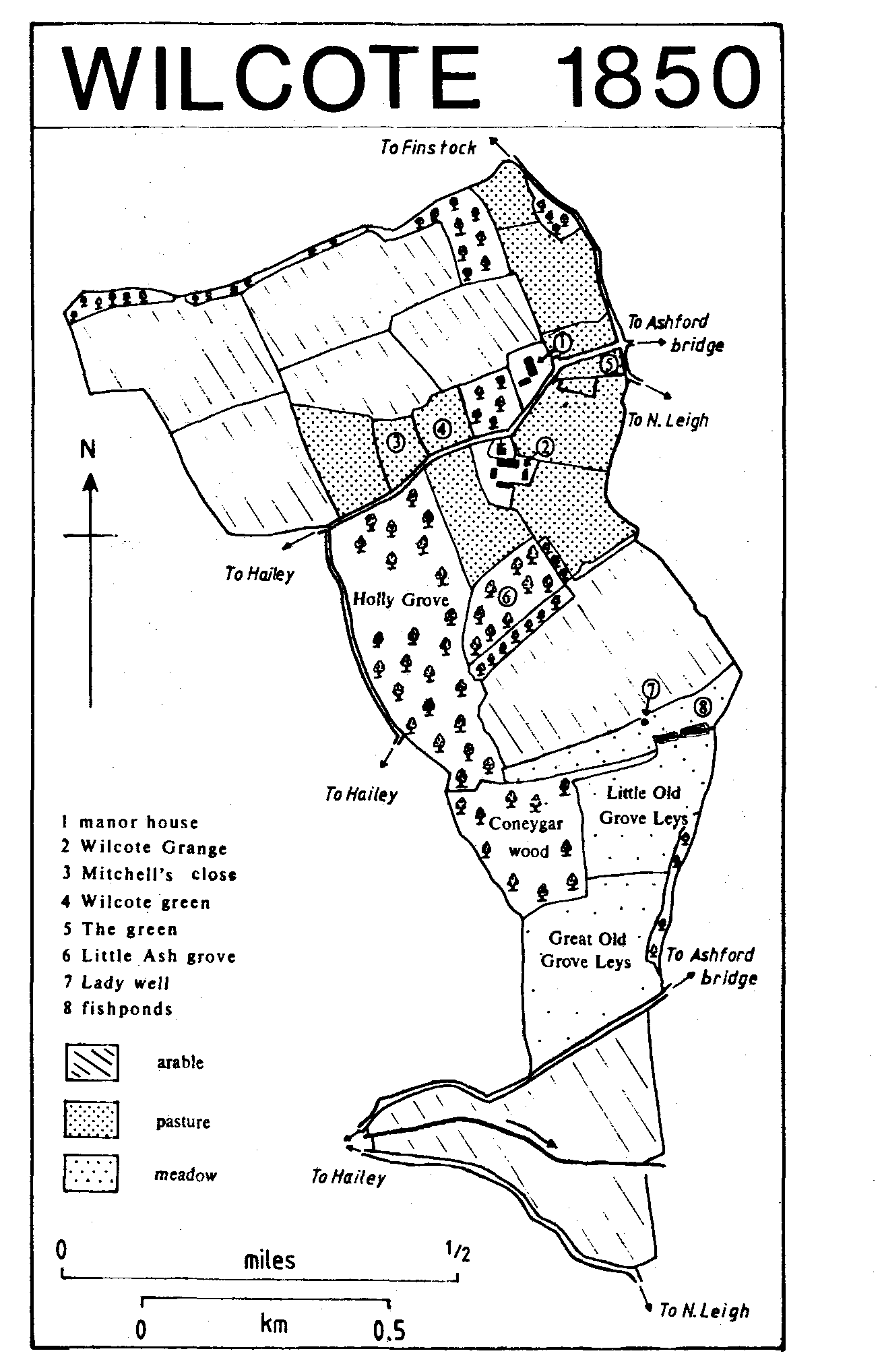
Wilcote 1850
Only two tenants were recorded at Wilcote in 1086. (fn. 74) By the mid 13th century there may have been a sharp increase, since 20 Wilcote men were cited for forest offences in 1245-6. (fn. 75) Possibly some were not from Wilcote parish but from the part of North Leigh known as Wilcote, near Wilcote House: (fn. 76) signs of occupation have been discovered around the crossroads on the parish boundary between the house and Wilcote Manor, (fn. 77) but only one of the Wilcote names of 1245-6 occurs in the list of North Leigh tenants in 1279. Probably the population of Wilcote parish was small: there were 5 tenants in 1279, when the return appears to be incomplete, recording only 2 ½ yardlands, and 7 or 8 taxpayers in the earlier 14th century. (fn. 78) Twelve people over the age of 14 were assessed for tax in 1377. (fn. 79) The population was little different in 1642, when 12 people, including, unusually, women, were recorded as taking the Protestation oath. (fn. 80) There seem by then to have been only four houses in the parish: (fn. 81) the manor house, Wilcote Grange, and, probably, the houses known from their 16th- and 17th-century occupiers as Joiner's and Mitchell's. Joiner's, a freehold of medieval origin, was said c. 1600 to be 'on the green'. (fn. 82) closes called the Green and Wilcote Green were in 1850 in the south-west angle of the crossroads and west of the manor house respectively. (fn. 83) Mitchell's presumably stood in Mitchell's Close, immediately west of Wilcote Green. (fn. 84) It or Joiner's was pulled down in 1701, (fn. 85) and the other, uninhabited in 1738, had gone by 1759. (fn. 86) The population of the parish remained c. 10 for the whole of the 19th century, with the Wellington and Pickering family at the manor house, and a tenant family at Wilcote Grange. A third household enumerated in 1861, that of a gardener, perhaps lived in part of the manor house. (fn. 87) A 'row of hovels' allegedly standing until c. 1890 near Lady well, where there are earthworks and widespread nettle growth, is not shown on maps. (fn. 88) The population rose to 15 in 1921 and 1931, but there were still only the two houses. (fn. 89) The church and Wilcote Manor are described elsewhere. (fn. 90) Wilcote Grange, southeast of the church, was so called by 1899, (fn. 91) apparently in the belief that it had been a grange of Cogges priory. (fn. 92) Though the priory briefly owned two thirds of the demesne tithes, (fn. 93) Wilcote Grange was until the 20th century part of the manorial estate. The house was built in the earlier 18th century with a main front of four bays facing east and a lower kitchen wing on the west. It was remodelled c. 1800 when two canted bays were added to the east front and when the staircase was rebuilt, perhaps as a consequence of the entrance being moved to the south side. The barn adjoining the Grange on the west and another to the south were converted into houses between 1985 and 1987, and other outbuildings have also been converted. A claim that the avenue running south was planted by William Poole (d. 1866), a Waterloo veteran, (fn. 94) is supported by maps of 1850, showing no trees, and of 1881, showing the complete avenue. (fn. 95) The earlier map may, however, be inaccurate and Poole's role exaggerated, for many of the trees are c. 300 years old. (fn. 96) The likely creator of an avenue of that antiquity is John Cary, lord of the manor in the later 17th century, a keen planter who is known to have laid out 'nurseries of walnuts and ashes' at Woodstock for Edward Hyde, earl of Clarendon. (fn. 97) The conversion of farm buildings and the building in 1938 of a pair of cottages west of Wilcote Grange (fn. 98) and in the 1950s of two bungalows across the road from Wilcote Manor have had little impact on the quiet air of a secluded private estate. The stone gateposts at the entrance to the parish east of the manor house appear to guard a private drive, and strangers hesitate before passing through.
Wilcote people, including the rector in 1362, were commonly cited for poaching and taking wood from the forest in the Middle Ages. (fn. 99) In the earlier 19th century the tenant farmer at Wilcote Grange, George Brown, was repeatedly fined for poaching. (fn. 1) In 1800 Wilcote was caught up in the widespread disturbances provoked by high prices and the scarcity of provisions: in September a group of protesters from Witney, allegedly 500 in number, came to Wilcote and forced a promise from the farmer there, presumably George Brown, to bring produce to Witney market at reduced prices. (fn. 2) Lady well has historically been the scene of rites similar to those held elsewhere in the Wychwood area, and possibly ancient in origin if not in form: on Palm Sunday children from Wilcote and Finstock processed with bottles containing liquorice down to and around the well before filling them with water to make Spanish juice. (fn. 3)