Pages 83-91
A History of the County of Chester: Volume 5 Part 2, the City of Chester: Culture, Buildings, Institutions. Originally published by Victoria County History, London, 2005.
This free content was digitised by double rekeying. All rights reserved.
In this section
WATER TRANSPORT
River Navigation
The site of Chester marked the division between the navigable waters of the upper Dee and those of the estuary; vessels might come to it from both upstream and downstream, but at Chester itself from the 11th century or earlier the river was blocked by a weir or causeway, passable only at the highest tides and probably built at a natural interruption in the watercourse. (fn. 1)
Although barges sailed on the river between Bangor bridge and Chester until the 19th century and pleasure craft plied upstream from the city thereafter, the estuary was always the more important waterway. (fn. 2) It gave access to the Irish Sea and made Chester for much of its history a main point of arrival and departure for travellers from and to Ireland. In Roman times there may have been a quay west of the legionary fortress, (fn. 3) but by the 12th century the main anchorage seems to have been to the south, marked presumably by the Romanesque arch of the Shipgate. (fn. 4) The course of the river downstream from Chester was always uncertain, and its shifting sandbanks were remarked upon as early as the 12th century. (fn. 5) In the endless movement of those 'skittering sands' lay a perennial problem for the city: the maintenance of suitable anchorages to accommodate sizeable ships. By the 13th century the earliest and nearest, Portpool, had been created at the western edge of the city liberties. (fn. 6) Thereafter anchorages were established further down the Dee, at Shotwick, Burton, Denhall (in Ness), Neston, Gayton, Heswall, 'Redbank' (later Dawpool) in Thurstaston, and Point of Ayr (in Llanasa, Flints.). (fn. 7) In the 14th and 15th centuries 'Redbank' was much the most important, but Burton and Denhall rose to significance in the early 16th century. Those closest to the city, Portpool and Shotwick, were affected by silting; they were disused from the later Middle Ages, and a quay established at Shotwick in 1449 proved of little value. The fluctuations in the fortunes of the others reflected a succession of shifts in the river's course rather than progressive silting downstream. (fn. 8)
The right to establish anchorages far beyond the limits of the city liberties was an aspect of Chester's control of the whole of the Dee estuary. The citizens' rights were first specified in the charter of 1354, which allowed them to levy tolls and other customs and to make attachments for offences committed in the water of Dee between the city and Arnold's Eye, at Hilbre Point, the extremity of the estuary. (fn. 9) The grant, which is generally taken to be the origin of the mayor's powers as 'admiral' of the Dee, claimed to continue ancient custom. (fn. 10) The citizens' privileges were clarified in 1506: they were to have the 'searching' of the Dee from Heronbridge to Arnold's Eye, oversight of nets, weirs, and fishing, and the collection of fines from all transgressions. (fn. 11) Heronbridge was on the boundary of the liberties upstream from the city. By the 17th century the citizens' rights were usually exercised by a water bailiff, appointed by the Assembly and often a serjeant-at-mace. (fn. 12) As a symbol of his authority the city in 1719 commissioned a silver oar, still in 2000 among the civic plate. (fn. 13)
The citizens' privileges appear to have overlapped with those of the serjeant of Dee. Robert of Eaton first laid claim to that office in the earlier 14th century, regarding himself as keeper of the river banks from Eaton weir to Arnold's Eye, with rights over fishing, wrecks, and ferries, and an entitlement to toll from every vessel. (fn. 14) The main obligation of the office, to keep the river clear of obstructions, was evidently a pressing matter when it was first recorded; in 1358, for example, the justice and chamberlain of Chester were ordered to seize nets and other fishing devices which impeded the progress of boats upstream to the Dee Bridge. (fn. 15)
The office of serjeant was retained by Robert's descendants, the Grosvenors, until the 18th century, with the assistance from the mid 17th century of the Chester fishermen's guild, the Drawers of Dee. (fn. 16) By then, however, the corporation appears to have been uncertain about the relationship of the Grosvenors' office to its own admiralty powers. In 1705, for example, the mayor claimed that the office of serjeant of Dee belonged to the city. The alderman of the Drawers of Dee, who was deputizing for Sir Richard Grosvenor, 4th Bt., responded by sailing alone from Eaton to Chester, and thence to Hilbre and back in the company of the Drawers, in the course of which he seized illegal fishing stakes. He conducted a similar progress in 1710. (fn. 17) The dispute was evidently over by 1722, when Sir Richard Grosvenor appointed as his deputy the mayor who had challenged him in 1705. By the early 19th century the Grosvenors had apparently given up their claims. (fn. 18)
In 1541 the corporation adopted a plan to build a new harbour some 10 miles down the Dee estuary at Lightfoot's Pool in Little Neston, and the king ordered 200 trees to be delivered to the mayor for that purpose. (fn. 19) In 1548, in response to a petition from the city for aid with the work, the orders were repeated and augmented by a grant of £40 for seven years. (fn. 20) Despite a further appeal for a royal grant in 1551, (fn. 21) the city was forced to raise funds locally; between 1555 and 1560 voluntary rates and special assessments were imposed on the guilds, parishes, and citizens, and special payments were exacted from members of the corporation. (fn. 22) Work was evidently well under way by 1565, when a salaried overseer was appointed. (fn. 23) In 1566, however, the 'great pier of stone' which formed the main feature of the haven was largely overthrown in a gale. (fn. 24) To repair the damage a further special assessment was made in 1568 on the citizens and the guilds, and councilmen were ordered to oversee the work at their own cost. (fn. 25) By 1570 much of the new quay had been finished. (fn. 26)
The New Haven, otherwise known as Neston Quay or New Quay, eventually comprised an anchorage protected by a stone pier. (fn. 27) The project, which was probably never completed, remained a constant burden on the city's finances throughout the later 16th century, despite appeals to the Crown for grants out of customs revenue in 1576 and 1589. (fn. 28) Its repair was aided by the Ironmongers' company in 1571, (fn. 29) and was the subject of further orders by the Assembly in 1576, 1587, and 1598. (fn. 30) The city's last recorded expenditure upon it was in 1604. (fn. 31) Although it remained in use until the 1690s or later, the New Haven's position as head of navigation for larger vessels was gradually undermined by the anchorage newly developed near by at Parkgate. (fn. 32) In 1763 the corporation granted the petition of one of its aldermen to use some of the stones of the pier, by then known as the Old Quay, to develop a colliery, and in 1790 it ordered that the remaining ashlar and other stone be valued and sold. It was finally disposed of in 1799. (fn. 33)
By the early 17th century, schemes were afoot to improve the Dee navigation. Commissioners of Sewers, appointed in 1607 to survey the river and remove obstructions, decreed that a breach of 10 yd. be made in the causeway at Chester. (fn. 34) Although favoured by the J.P.s of Flintshire and Cheshire, the order was vigorously opposed by the city corporation, two city companies, and the proprietor of the Dee Mills, on the grounds that the removal of the causeway would ruin the mills and damage the new system of water supply. (fn. 35) In 1609 the privy council quashed the commissioners' order.
In 1646 the citizens of Chester themselves successfully petitioned parliament to be allowed to demolish the causeway and the mills, (fn. 36) but the only effect of the several breaches made was to make the river more shallow and sandy. Despite the appointment of labourers to carry out the work in 1648, the mills and causeway survived. (fn. 37)
In 1666 the citizens alleged that the river had become so shallow that vessels as small as 20 tons could no longer reach Chester, and in 1670 they were granted leave to bring a Bill before parliament to improve the navigation. (fn. 38) The engineer Andrew Yarranton, who surveyed the estuary in 1674, was the first to suggest the solution ultimately adopted, namely the construction of a new channel along the Welsh side of the estuary, reclaiming 3,000 a. of potentially rich arable. (fn. 39)
In the late 1680s and early 1690s fresh proposals were put to the corporation for making the Dee navigable and reclaiming land. (fn. 40) Although the schemes aroused the opposition of those claiming rights on the sands and marshes of the estuary, in 1698 the corporation agreed with Francis Gell, a London merchant, that in return for a grant of tolls and reclaimed land he should make the Dee navigable for vessels of 100 tons at all tides. (fn. 41) An Act of 1700 authorized the corporation to collect special dues on coal, lime, and limestone to finance a new channel, and to appoint seven commissioners to oversee the work; it also provided for ferries to replace the old fords. (fn. 42) After a break of six years the work begun by Gell restarted in 1708 with a new undertaker, Nicholas Jennings, who promised to complete it in three years. Little was achieved, however, and work probably largely ceased in 1712, (fn. 43) though maintenance continued in the late 1710s, (fn. 44) when the city's agents were still collecting the duties intended to pay for the works. (fn. 45) The work made the city's wharves and warehouses near the Watergate obsolete by 1707, but the replacement wharf constructed near the Roodee was destroyed by flooding in 1720, (fn. 46) and by 1730 almost no ships came up to the city. (fn. 47) Instead most goods were transferred to lighters or carts at Parkgate. (fn. 48) About 1730 navigation to Chester ceased altogether after breaches in the dykes destroyed the channel. (fn. 49)
In 1732 the project was revived by Nathaniel Kinderley, who sought funding to make the river navigable for ships of 200 tons. He followed Yarranton in proposing a new cut across Saltney marshes and estimated that c. 6,000 a. would be reclaimed to set against the cost. Despite considerable opposition from interests in Liverpool and Parkgate, in 1733 an Act authorized Kinderley to cut a new channel from Chester towards Flint to a depth of 16 ft. at a moderate spring tide. Once the new channel was open, the 40 undertakers of the project, of whom fewer than a third were Chester men, were authorized to collect dues from ships using it. They were also granted the profits from any land reclaimed. (fn. 50)
Cutting began in 1734, and the river was diverted into its new channel in 1737. In 1741, by a further Act, the undertakers, who needed to raise additional capital, became the River Dee Company. (fn. 51) The cost had proved much greater and the income from the new dues much less than expected. An Act of 1744 reduced the levies in an attempt to encourage trade, and they remained insufficient to meet outgoings, enlarged by the requirement to maintain two ferries and the roads which led to them. (fn. 52) Reclamation involved the company in expensive work to restore boundaries and roads disrupted by the new channel, which as a result was not properly maintained. In 1752 the company claimed to have lost £60,000. It eventually agreed to pay Sir John Glynne of Hawarden a yearly sum to compensate for his loss of common rights and to maintain a new south bank. Since that sum exceeded the receipts from the tolls, the company remained in difficulties and apparently paid no dividend until 1775. (fn. 53)
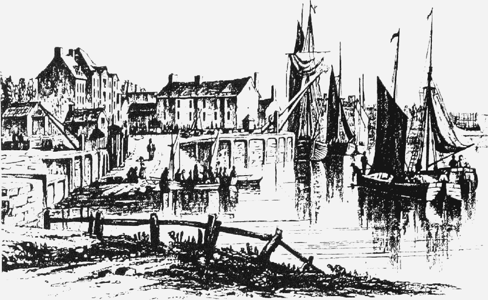
New Crane Wharf, mid 19th century
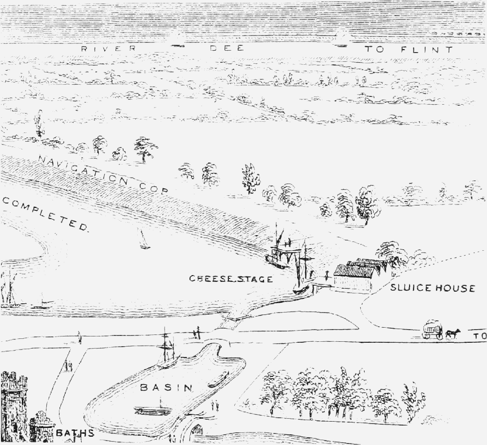
Cheese Wharf, 1867 (looking west)
The new cut nevertheless made the city accessible during spring tides to ships drawing up to 15 ft. in the 1770s. (fn. 54) By the mid 1740s a wharf had been reestablished west of the Roodee and there were large timber yards near by. About 1760 the city built a new warehouse for cheese, with its own quay, just to the north, and was planning a further dock, warehouses, and a new road from the Watergate, later called New Crane Street. (fn. 55) By 1781 New Crane Wharf was lined with the warehouses of the city's merchants and capable of taking vessels up to 350 tons. (fn. 56)
The Act of 1744 empowered the corporation to appoint one of two supervisors who were to take soundings in the river and report to the city or county justices if at three successive tides the depth of the channel fell below 15 ft. (fn. 57) The city, however, took little interest in the river or the company in the century after the Act. By the early 19th century, the old watercourse had largely silted up and the company's maintenance of the new channel was under attack. Although Thomas Telford, who worked for the company between 1817 and 1828, expressed himself satisfied with the state of the river, by 1850 it was regarded as hazardous. (fn. 58)
In 1835 the city's admiralty powers were abolished and in 1841 its supervisory role over the river was vested in a council committee. (fn. 59) The corporation remained concerned about the company's neglect of the navigation, and there were several schemes for its improvement in the 1830s and 1840s. (fn. 60) In 1846 the Tidal Harbours Commission criticized the company for its interest in land reclamation at the expense of the new cut, and in 1850 an Admiralty inquiry into the Dee conservancy condemned the ruinous state of the navigation, attributing it to the negligence of the company and to the long-standing apathy of the city council. (fn. 61) Continuing dissatisfaction with the state of the navigation led in 1889 to the transfer of the company's powers to the Dee Conservancy Board, which also became the pilotage authority for the river until 1938, when that power was vested in Trinity House. In 1965 the board was replaced by the Dee and Clwyd River Authority, after 1974 a division of the Welsh Water Authority. (fn. 62)
Canals
Improvements to the river Weaver after 1730 served to channel trade from central Cheshire away from Chester to the Mersey, (fn. 63) and the Trent and Mersey Canal Act of 1766 threatened to strengthen still further the dominance of Liverpool over the Dee. (fn. 64) Despite that threat, no apparent opposition to the Trent and Mersey Bill was voiced in Chester, but within two years of its passage there was a proposal for a canal to link Chester to the new canal at Middlewich and surveys were commissioned from the canal engineer James Brindley. (fn. 65) Jealous of their own traffic, the Trent and Mersey company and the duke of Bridgewater, Francis Egerton, owner of the Bridgewater Canal which connected with it, opposed any link with the proposed Chester Canal. (fn. 66) The latter was nevertheless authorized in 1772, (fn. 67) permitting the building of a canal 14 ft. wide from Chester to Nantwich and Middlewich. (fn. 68) Most of the capital was raised in Chester or from the Cheshire gentry. (fn. 69) The project was undermined, however, by a requirement that the new canal should keep at least 100 yd. away from the older undertaking at Middlewich. As a result, the Middlewich branch was not begun. There were also arguments with the River Dee Company over access to the river at Chester, and many engineering problems. Although the canal between Chester and Nantwich opened in 1779, it was a dead end and attracted little traffic. The project was a financial disaster and during its first 10 years was threatened with closure. (fn. 70) No dividends were paid during the company's independent existence between 1772 and 1813. (fn. 71)
Within the city the new canal changed the townscape substantially. From a tidal basin linked to the Dee north of Crane Wharf the canal climbed a staircase of five wide locks, the largest in Britain when built, with chambers cut from the solid sandstone. It then entered a deep cleft below the northern city walls, a section expected to need a tunnel but which proved to be along the rubbish-filled Roman defensive ditch. (fn. 72) The cutting was spanned by Northgate Street bridge and from 1793 by a narrow stone footbridge, designed by Joseph Turner, architect of the new Northgate, linking Northgate gaol and Little St. John's chapel in the Blue Coat school building. (fn. 73) From the main city wharf, later called Victoria Wharf, east of Cow Lane bridge the canal took a straight course eastwards across the fields and gardens north of Foregate Street and Boughton, beginning a steady climb to Nantwich at Hoole Lane lock. (fn. 74)
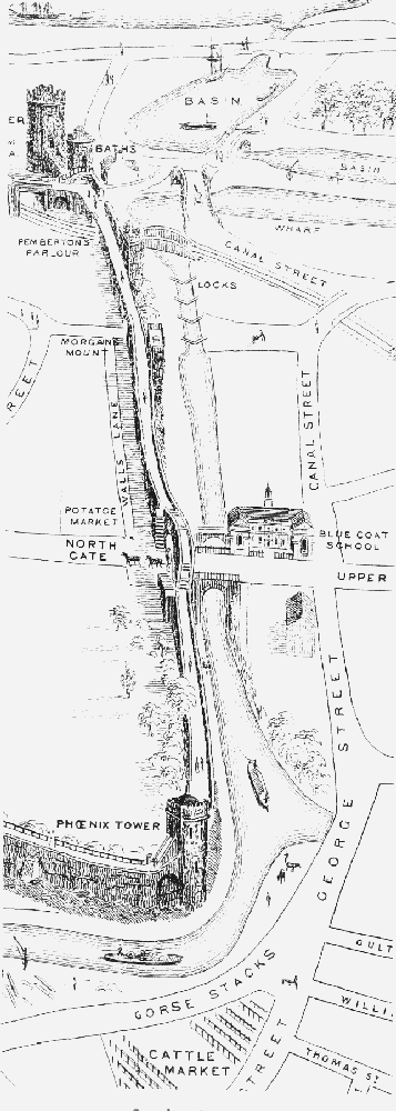
Canal and north city wall, 1867
Chester's canal was saved from ignominious closure by the 'Canal Mania' of the 1790s. The Ellesmere Canal Act was passed in 1793, (fn. 75) and although the scheme took 12 years to complete (fn. 76) it ultimately connected the city to a much wider hinterland. The first section, opened in 1795, linked Chester to the Mersey at Netherpool (later Ellesmere Port). Connexion to the Chester Canal and the Dee involved substantial works, finished in 1797, (fn. 77) which resulted in the unusual layout still in use in 2000. The Northgate staircase was severed below the third lock, the lower two locks were filled in, and the Chester Canal swung sharply north to an end-on junction with the Ellesmere at Tower Wharf. The bend proved awkward for horse-drawn boats and was made worse when the railway cut across the cramped site below the locks, reducing the available space still further. (fn. 78) The link with the river for both canals diverged from the Wirral line at Whipcord Lane and fell parallel to the main route through two locks to reach the tidal Dee Basin. (fn. 79) The tidal basin itself had proved difficult of access and prone to silting, and a new entrance with a tidal lock was opened in 1801 south of the original line, no trace of which survived in 2000. (fn. 80) A dry dock for repairing canal boats was built at the junction between the two branches in 1798 and a large boat-building yard developed on the west bank, while the North Basin and warehouses were built on the east bank by Tower Wharf in 1802. (fn. 81) That basin was filled in and the warehouses were demolished during the 20th century but the dry dock survived in 2000 and plans were in hand to restore the basin as additional mooring space for pleasure craft.
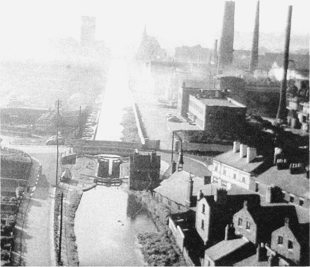
Canal, west of waterworks, 1957: Steam Mill (left), leadworks (right)
The Wirral line of the Ellesmere Canal proved a great success. It was navigable by flats, the standard craft of the Mersey and Weaver, (fn. 82) and goods could be brought directly to Chester by water from Liverpool and other points on the Mersey. Lancashire coal, for example, became cheap enough to compete with that from north Wales. (fn. 83) A service of passenger packet boats was provided from the opening of the canal, the journey to Liverpool optimistically timed at three hours, and 15,000 passengers a year were using it by 1801. (fn. 84) The service continued until the opening of the Chester and Birkenhead Railway in 1840. (fn. 85) The new link to the Mersey attracted a leadworks and corn mills to the canal side. (fn. 86) Successful as it was, the new canal served ultimately to demonstrate that Chester's waterborne traffic could be carried more effectively through Liverpool and the Mersey than through its own port. Although the increase in imported grain after 1860 initially made the canal more important, eventually it became more economic to open new mills on the Mersey and the canal-borne trade to Chester ceased, probably around the time of the First World War. (fn. 87) The trade in timber brought from the Mersey to the yards at Cow Lane bridge also ceased soon after 1918. (fn. 88)
The opening of the Wirral line of the Ellesmere Canal revived the debt-ridden Chester Canal, (fn. 89) and its prospects improved further with the expansion of the Ellesmere company's system. In 1806 Chester was linked by a circuitous new canal (later called the Llangollen Canal) to the Denbighshire coalfield near Ruabon, as well as to Whitchurch (Salop.) and Montgomeryshire. It joined the Chester Canal at Hurleston near Nantwich. Plans for a direct link between Chester and Wrexham foundered because of cost and engineering difficulties. (fn. 90) The interdependence of the Chester and Ellesmere companies led to their merger in 1813. (fn. 91) In 1826 the passing of the Birmingham and Liverpool Junction Canal Act engendered a scheme linking the end of the Chester Canal at Nantwich with the main canal system at Autherley Junction near Wolverhampton. (fn. 92) The name of the new canal (Birmingham and Liverpool), opened in 1835, was indicative of its primary objective, and Chester was merely an intermediate point on its route. Faced with a new short route from the Midlands to the North-West, the Trent and Mersey Canal agreed to the completion of the Chester Canal's Middlewich branch and the disputed junction, though stiff tolls for traffic passing that way were exacted. The link opened in 1833, but the original aim of diverting Trent and Mersey traffic to Chester and the Dee had vanished. The main impact on the city's canal trade was to bring salt in bulk from the Middlewich area for local distribution from a wharf west of Cow Lane bridge, a traffic which ceased soon after 1918. (fn. 93)
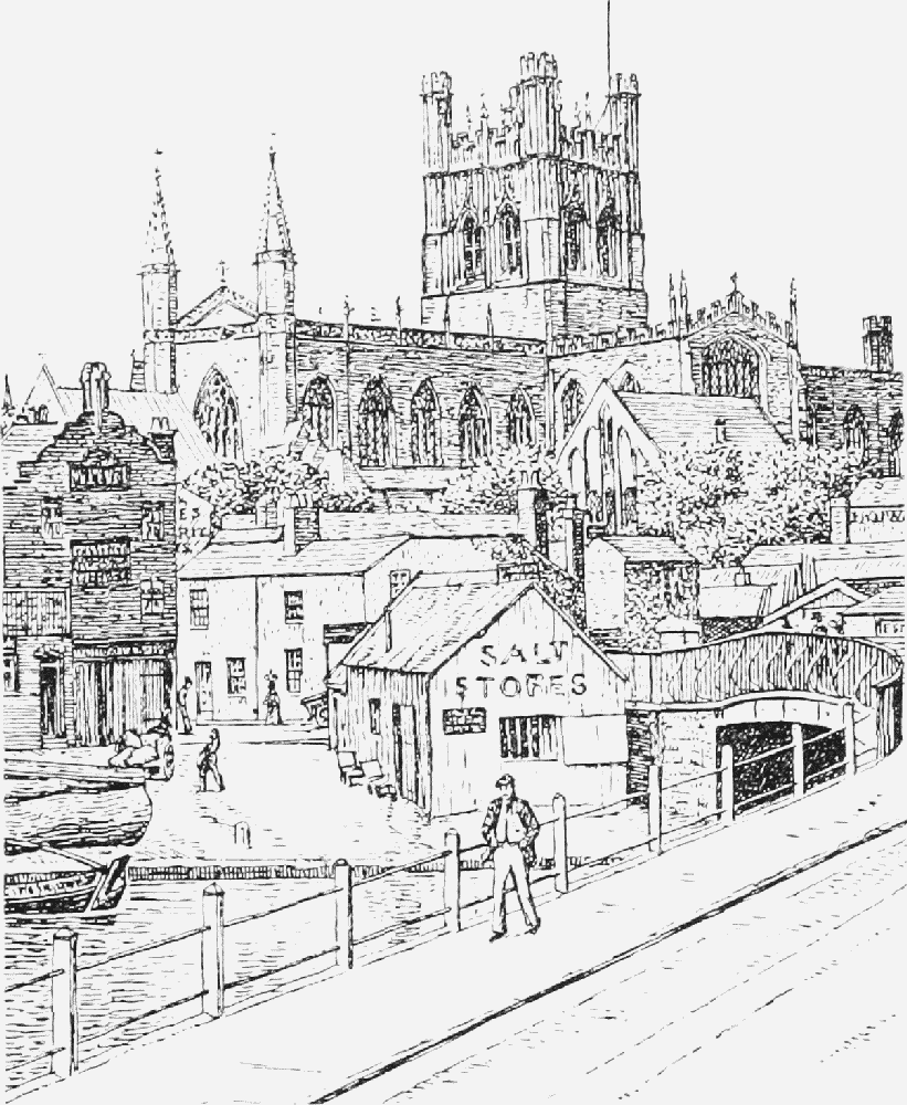
Salt warehouse and timber yard, Cow Lane bridge, 1903
To counter the threat from railways, the Chester and Ellesmere and the Birmingham and Liverpool Junction canals united in 1845, becoming the Shropshire Union Railways and Canal Company in 1846. The new concern was immediately leased in perpetuity to the London and North Western Railway, but the Shropshire Union continued to have considerable autonomy and was operated vigorously because much of its network lay in the territory of the Great Western Railway. (fn. 94) A direct benefit to Chester was the location of the administrative headquarters of the whole Shropshire Union system at Tower Wharf. The company developed its own carrying business, and by 1870 had almost a monopoly of traffic on both the wide canal to Nantwich and the narrow canal beyond and to Middlewich. The boats were controlled from Chester (fn. 95) and many were built at the company's boatyard in the city. (fn. 96) From 1878 the city council was responsible for registering and inspecting the company's craft under the provisions of the Canal Boats Act, 1877. (fn. 97) Two hundred and fifty-two boats were working in 1878, and the number had risen to c. 400 by 1895. (fn. 98) Wide boats and flats traded between the Mersey Docks, Ellesmere Port, and Chester, the main traffic to Chester being in grain, fertilizer, (fn. 99) timber, and pig lead. (fn. 100) For narrow boats, engaged almost entirely in through traffic between Ellesmere Port and the Midlands or the Welsh Borders, Chester was merely a port of call and registration.
Chester's significance for the Shropshire Union system was primarily administrative, a function which proved vulnerable. The boatyard was sold in 1917, (fn. 101) and in 1921, faced with rapidly rising losses, the company hastily abandoned its carrying operation. (fn. 102) Although some of the fleet carried on under other owners, (fn. 103) trade on the canal to and through Chester had been dealt a mortal blow. Between 1922 and 1931 only 13 boats were added to the Chester register, while in 1925 alone 86 were scrapped. (fn. 104) The Shropshire Union company was taken over by the L.N.W.R. in 1922, and although part of the Shropshire Union system continued to be managed from Tower Wharf, Chester ceased to be the canal's head office. (fn. 105) After nationalization in 1948 most administrative functions were concentrated in Northwich. (fn. 106) Trade through the Dee branch ended in 1939 when Courtaulds' steam flats stopped running between the Mersey and Flint, and the last regular commercial traffic on the main line disappeared in 1957, (fn. 107) although carriage by narrow boat continued spasmodically until the early 1970s. (fn. 108) The demise of goods traffic was offset by the growth of pleasure boating, a development pioneered in 1935 by Inland Hire Cruisers of Christleton. (fn. 109) The canal's environmental and tourist value was recognized in the 1960s, and it was still much used and well maintained in 2000 (Fig. 49). (fn. 110)
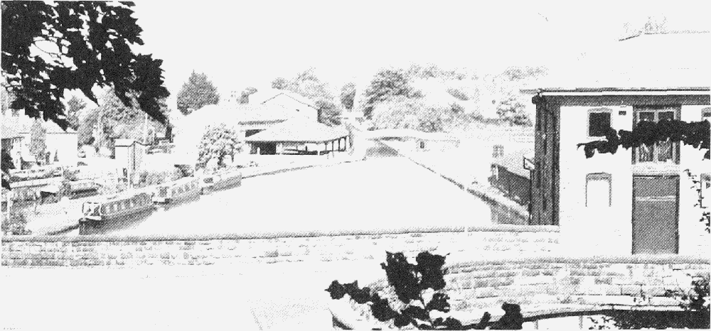
Visitors' canal boats at Tower Wharf


