Pages 402-410
An Inventory of the Historical Monuments in Dorset, Volume 2, South east. Originally published by Her Majesty's Stationery Office, London, 1970.
This free content was digitised by double rekeying and sponsored by English Heritage. All rights reserved.
In this section
52 WOOL (8486)
(O.S. 6 ins. aSY 88 NW, bSY 88 NE, SY 89 SW)
The modern parish of Wool, 5 m. W. of Wareham, covers some 3,000 acres on both sides of the river Frome between 200 ft. and 50 ft. above O.D. The S. part slopes from Chalk in the S.W., through areas on Reading Beds and London Clay, well-wooded to the E. around Woodstreet, to the river terraces along the Frome; the N. part, beyond the river terraces, is an extensive area of heathland on Bagshot Beds.
Recent boundary changes in the S.W. have resulted in considerable gains, including the hamlet of East Burton, from Winfrith Newburgh parish. Besides E. Burton, there were three early settlements in the S. part of the parish: Wool village itself is one of these. The second settlement, half a mile to the E. of Wool, was apparently completely removed when Bindon Abbey was transferred here in 1172 from its original site at Little Bindon in West Lulworth. The third settlement, Woodstreet, is now represented by a farm of c. 1600; it is situated in a small valley on Reading Beds in the E. of the parish.
The N. part of the parish was always the land associated with Bovington, a small Domesday settlement on a river terrace of the Frome, now only a farm.
The parish church, the ruins of Bindon Abbey and the adjacent house are the principal monuments.
Ecclesiastical
a(1) The Parish Church of The Holy Rood stands at the S.E. end of the village. The walls are of rubble including much carstone, with freestone dressings; the roofs are covered with lead and tiles. The church comprises a chancel, N. chapel and vestry, nave, N. and S. aisles and W. tower. The two middle arches of the N. arcade of the Nave are of the 13th century; the North Aisle was rebuilt and extended to the W. in the 15th century presumably in part on the 13th-century foundations of the N. wall since the aisle is so narrow; the West Tower was added at the same time. Much rebuilding was done by John Hicks of Dorchester following a faculty of 1865: the nave and N. aisle were extended E., the Chancel was rebuilt and extended to the E. by 12 ft. and the North Chapel, Vestry, North Porch and the South Aisle and arcade were added or rebuilt. Drawings dated 1864 of the N. and S. sides of the church before restoration hang in the tower.
Architectural Description—The Chancel (19¼ ft. by 14⅓ft.) has in the N. wall a reset late 14th-century arch, two-centred and of two continuous chamfered orders, the inner with moulded bases. The reset and much restored late 14th-century chancel arch has an open arcade of three two-centred arches of two chamfered orders springing from octagonal piers continuous with the inner order and with 19th-century moulded bases, and from restored chamfered responds; a two-centred arch encloses a solid tympanum above the arcade. In the E. wall of the modern vestry is a reset and much restored 15th-century window of two lights.
The Nave (42½ ft. by 17 ft.) has a N. arcade of four bays; the easternmost bay is modern; the two middle bays are of the 13th century with two-centred arches of two chamfered orders springing from a circular pier and semicircular responds with moulded capitals and bases with spur-ornaments; the westernmost bay is a 15th-century addition, approximately a copy of the earlier work, but in freestone, and with a decorative carved corbel at the springing on the W. The S. arcade was built c. 1865.
The North Aisle (6¾ ft. wide) has, in the E. wall, a reset late 14th-century arch, triangular and of two chamfered orders; the responds are modern. In the N. wall are three 15th-century windows; the easternmost, formerly in the chancel, is of two cinque-foiled lights with a triangular rear arch; the other two are both of three cinque-foiled lights in a square head with moulded reveals and triangular rear arches; the 15th-century N. doorway has stop-moulded jambs and a triangular head.
The South Aisle is modern but reset in the S. wall are two three-light windows and a doorway between them similar to those opposite in the N. aisle.
The West Tower (12 ft. square) is of the 15th century and of three stages with a double-moulded plinth, embattled parapet and inset angle buttresses to the first two stages; a semi-hexagonal vice with pyramidal ashlar roof projects from the S. side. The two-centred tower arch is of three moulded orders, the innermost springing from three-quarter-round attached shafts with moulded and enriched capitals and moulded bases, the two outer continuous. The W. window is of three trefoiled lights with vertical tracery in a two-centred head with a label. The second stage has square-headed lights in the N. and S. walls. The bell-chamber has, in each of the N., S. and W. walls, a window of two cinque-foiled lights with pierced stone louvres and blind tracery in a two-centred head; in the E. wall is a quatre-foiled opening.
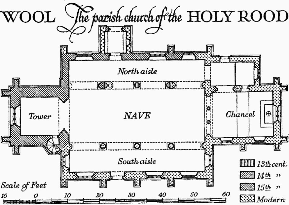
Wool, the Parish Church of the Holy Rood
The North Porch has been rebuilt but incorporates a 15th-century quatre-foiled opening in the E. wall and an outer archway, two-centred and of two moulded orders; the inner order springs from attached shafts with capitals and bases.
Fittings—Bells: six; 2nd by John Wallis, 1606; 3rd by William Knight, 1738; 4th by John Wallis, 1606; 5th by Thomas Purdue, 1659. Font (Plate 8): built against pier of N. arcade, semi-octagonal bowl with splayed underside, quatre-foiled circle in each face, plain stem and square base, 15th-century. Monuments: In tower—on N. wall, (1) to Stephen White Warne, 1825, white marble tablet on grey marble backing; (2) to Eliza Raven, widow of above, 1848, similar. Plate: includes a cup and cover-paten of 1571 and a paten of 1816. Royal Arms: In N. aisle, painted wooden panel, George III before 1800, and inscribed with the name of the churchwarden. Scratch Dial: on tower, on S.W. buttress, reset inverted. Miscellanea: In N. aisle, in rear arch of centre window, mason's rejected stone fragment with incised liningout for cusped window(?) head and spandrel. Loose in N. aisle, cresset-stone with four holes for wicks. In churchyard, W. of tower, stone with square socket-hole perhaps for base of cross. Now in Dorchester Museum, altar frontal (Plate 31) made up from 15th and 16th-century vestments in eight strips, with ten figures.
a(2) Burton Church (1 m. W.) stands at the S. end of the village of East Burton. The walls are of squared and coursed local rubble with dressings of Ham Hill stone; the roof is slate-covered. The church is orientated N.–S. Building commenced in 1839 when the Dorset County Chronicle announced (31 Jan. 1839) that 'a plan of an elegant, chaste and cheap church has been furnished gratuitously by J. T. Parkinson of Jersey'; the church came into use in the following year as a chapel-of-ease to Wool.
Architectural Description—The plan comprises one rectangular compartment (20 ft. by 40 ft.) with a porch at the S. end. The walls are divided by tall single-stage buttresses and have a plain plinth; the windows in the E. and W. walls are of two lights in two-centred heads with moulded labels. The N. and S. walls are gabled; in the N. wall is a blind window with two-centred head; in the S. gable is a blind quatrefoil and above it a small wooden bell-cote. The roof has six queen-post trusses with pendants. The S. porch (8½ ft. by 8 ft.) is gabled and has a doorway to the W. under a four-centred head and a blind doorway to the S.
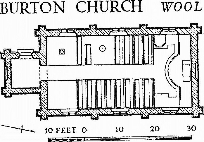
Burton Church, Wool
Fittings, all c. 1840—Bells: one uninscribed. Brasses: at S. end, tablet recording erection in 1840, with 120 sittings, and a grant from the Incorporated Church Building Society. Communion Rails: with plain octagonal balusters, carried forward in an arc in front of the communion table. Communion Table: small, 3 ft. 4 ins. by 2 ft. 2 ins.Doors: in S. doorway and S. porch, with vertical mouldings. Font: of stone with round moulded bowl and stem. Plate: includes a cup, undated, and a paten, plate and flagon of 1840, each recording their donation 'to the new Protestant chapel at East Burton by Mrs. Rebecca Scott relict of James Scott Esqre. of Winfrith Newburgh' on the day of consecration, 7 Sept. 1840. Pulpit: of wood, semi-octagonal.
b(3) Bindon Abbey, ruins (½ m. N.E.), stands in the grounds of 'Bindon Abbey', (7) below. The walls are of carstone rubble and carstone ashlar, the latter facing rubble composed mainly of flint, with decorative dressings of Purbeck stone. The abbey was founded in 1149, for Cistercian monks, by William de Glastonia at Little Bindon on the E. side of Lulworth Cove (Lulworth, West, (2)), and was colonised from Forde Abbey. The community was moved to the site of the present ruins in 1172 by Roger de Newburgh. The greater part of the buildings, including the Church, Chapter-house and E. range and Cloister, was erected in the late 12th to mid 13th centuries. A grant of 30 cartloads of lead in 1213 suggests the completion of roofs at that time, and a grant of timber by Henry III in 1238 was specifically for the church (Cal. Close Rolls 1237—42, 109). There is now little recognisable work of any later date. The abbey was finally dissolved in 1539 and then granted to Sir Thomas Poynings. Coker (Survey of Dorsetshire, 77) refers to a fair house which was built by Thomas, Viscount Bindon, out of the ruins of the abbey. Accounts (in D.C.R.O.) dated 1608 from Hugh Hoble for making and Snoock and Baskom for setting stone-mullioned windows 'about Byndon Gallery', including one at the N. end of six doubletransomed lights, show that it was, or then became, a house of some pretension. It was acquired by Humphrey Weld in 1641 and burnt down in the Civil War in c. 1644 (Hutchins I, 349).
In 1785 the account book of Thomas Weld (in D.C.R.O.) records taking down stone at Bindon abbey for work at Lulworth castle (Lulworth, East, (3). The present house, 'Bindon Abbey', was built in 1794–8.
The abbey has suffered extensive demolition particularly in regard to the church and the buildings S. and W. of the cloister, none of the walls now standing more than 8 or 10 ft. high, except at the W. end of the church. A view in Hutchins (1st ed. I, opp. 130), dated 1773, shows a nave arcade of four pointed arches still standing with a clearstorey above it, rather less than was recorded by Samuel Buck in 1733 (Hutchins I, 352); all this has now gone. The plan is of the usual Cistercian type with the Church on the N., the Chapterhouse and Dormitory range on the E., the Frater on the S. and the Cellarer's range on the W.
The interest of the remains lies chiefly in the plan and in certain details of the Chapter-house.
Architectural Description—The Church consisted of a short aisleless chancel, N. and S. transepts with two chapels on the E. side of each, and an aisled nave. The Chancel (32½ ft. by 28 ft.) has the walls standing some 4 ft. high but mostly exposed only on the inner face. In the N.E. angle is part of an angle-shaft with hold-water base and adjoining it the moulded angle of a recess or wall-arch in the E. wall. Against the S. wall is the lower part of a projecting pilaster with moulded angles. Of the Crossing (23½ ft. by 27 ft.) there remain only slight traces of the S. respond of the E. archway.
The North Transept (23½ ft. by 27½ ft.) has now no features. To the E. of it are two rectangular Chapels (11 ft. by 12¼ ft.) divided by a solid wall. Each has traces of vaulting shafts in the E. angles and an altar, and the S.chapel retains remains of the S. respond of the archway into it and of a double piscina in the S. wall. The South Transept (23½ ft. by 26¾ ft.) has, in the S. wall, a double recess with half-round arches and two chases for shelves in the dividing pier; further W. is a doorway to the Sacristy adjoining on the S., and W. of this is the start of the wall formerly supporting the night stairs to the Dorter. E. of the transept are two Chapels similar to those off the N. transept though with remains of vaulting shafts, an altar and a S. arch respond only in the S. chapel.
The Nave (121 ft. by 27 ft.) has, still standing some 25 ft. high, the remains of the deep W. respond of the N. arcade together with the adjoining portion of the W. wall, in which is the jamb of the W. window. Of the N. and S. arcades only the sub-base of the first pier on the N. and the moulded base of the fourth pier on the S. survive. The latter retains the matrix of an octagonal shaft. They show that the arcades were in seven bays on a module of some 14¼ ft. The remains of the base of the pulpitum suggest that the original structure was extended E. in the first half of the 14th century to fill most of the second and third bays. The two Aisles (11 ft. wide) are much destroyed except for parts at the W. end; both were divided by screen walls near the pulpitum. In the N. aisle are the remains of the matrix of a circular W. window, and in the S. aisle there are traces of the two entrances from the cloister and, in the W. wall, the jambs of a doorway of two chamfered orders.
The Cloister (90 ft. square) has now no remains of the arcade-wall in situ. Loose fragments include several bases of coupled shafts and a square base from an angle of the cloister arcade. The alley paving was taken to Lulworth castle (Hutchins 1st edn. I, 140).

Bindon Abbey
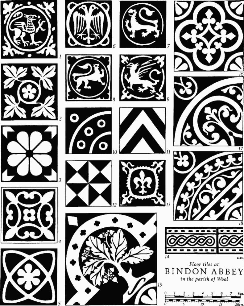
Floor Tiles at Bindon Abbey in the Parish of Wool
The East Range has, next to the transept, a small Sacristy or Book-room. It has traces of a barrel vault, a doorway from the cloister and a second doorway from the chapter-house. In the E. wall was an arched recess. The Chapter-house (40 ft. by 23¼ ft.) projects to the E. of the range and is of two main bays with a narrow bay to the W. which was bridged for a cross passage above. The room was entered from the cloister by a central doorway between two low open arches on dwarf walls which thus cleared the intrados of the bridge behind; of these only part of the S. respond of the S. opening now remains (Fig. p. 418); it has three squat attached shafts with moulded bases and scalloped capitals. The bridge in the W. bay, carrying the passage over from the night stair to the Dorter, was supported on a broad arch of which the springing can be seen against the N. wall. The rest of the chapter-house was stone-vaulted in two bays with roll-moulded ribs, springing from grouped shafts in the middle and angle-shafts at the ends. The shafts (Plate 204) generally are recessed back in the wall so as not to interfere with the benches below; the shafts have moulded bases, and one capital, of enriched scalloped form, with enriched abacus, survives on each side. There are remains of two single-light windows in the E. wall and of one in each side wall in the projecting bay. The splays of the S. window are moulded and have lozenge enrichment. The chapter-house repeats the recessed shafts seen in the corresponding position in the mother-house of Forde Abbey and in both places thenormal Cistercian aisled plan is abandoned.
To the S. of the chapter-house is a parlour or passage-room probably leading to the Infirmary to the E. The jambs of the E. doorway remain with traces of others in the S. and W. walls. S. of the passage is a small room with a loop-window on the E. and a doorway in the S. wall; on the external face of the E. wall is a recess or locker. The rest of the ground floor of the range is occupied by a single apartrment, forming an undercroft to the Dorter, perhaps the novices' day-room; it is of five bays. It had a central row of columns and a groined vault; the moulded bases of three circular columns remain and the vault sprang from corbels against the walls. The doorway from the cloister has jambs of two recessed orders and to the S. are the chamfered jambs of a second doorway; in the E. wall are remains of a window between two blocked doorways. In the S. wall are remains of two windows. The Dorter occupied the floor above, but there are no remains of this nor of the Rere-dorter which perhaps extended to the E.
The South Range has been almost completely destroyed except for part of the wall towards the cloister. At its E. end are the lower steps of the day stair from the Dorter; adjoining them was the Warming House. To the W. of this was the Frater built at right-angles to the cloister, and beyond again to the W. were the kitchens, where fireplaces with ovens and various footings were uncovered in 1966, though these may represent post-mediaeval alterations. The West Range is much destroyed except for part of its E. wall and other fragments. The part N. of the entry had a vaulted undercroft, and traces of three bays with their vaulting- shafts survive.
Fittings—Brasses and Indents. Indent: in N. chapel of S. transept, of brass of Abbot Richard de Maners, c. 1310; Purbeck marble slab with indents for figure holding a crozier and border inscription in separate capitals: ABBAS : RICARDUS: DE [:] MANERS : HIC : TUMULATUR: AD:PANAS : TARDUS : DEUS : H[u]NC : SALVANS : TUEATUR (Plate 203). Coffin: in chancel, with shaped head. Coffin-lids: in chancel, (1) plain; in chapter-house, (2) with traces of cross; (3) with cross with enriched head and foliated stem; (4) ridged and carved on each side with a pair of wyverns with intertwined tails (Plate 203); probably all 13th-century. For grave with unmortared sides excavated at entrance to presbytery, see Dorset Procs. LXXXII (1961), 88. Monument: now in S. transept, in S. wall, recumbent figure (2¼ ft. long) (Plate 203) wearing monastic habit, with hands now broken clasped on breast, to one side a staff, perhaps part of crozier, feet resting against a block carved with two arched panels; figure on pedestal base, 13 ins. high, with top and base moulded on three sides; mid 14th-century figure and pedestal, all cut out of one stone, now fractured. Tiles: In quire, (Fig. p. 405, Nos. 16–18) set diagonally, 14th-century, much damaged. In frater, (ibid., Nos. 1–14) set parallel with N. wall in panels divided by plain borders, 13th-century; (15) 14th-century. Miscellanea: A number of moulded stones of various dates lie about the site.
b(3a) Bindon Mill, house and water-mill 60 yds. N. of the Abbey Church, with rubble walls, is of mediaeval origin and incorporates a pointed archway in the E. wall of the house. Cut on a voussoir of this arch is the date 1770 to which date much of the present structure belongs. The water-wheel and later turbine has been removed. The Bridge nearby is inscribed with the initials and date EW 1756.
Secular
a(4) School and Schoolhouse, on W. side of High Street, with rubble and brick walls rendered in stucco and roof covered with slate, are of the early 19th century. The two-storey house and the single schoolroom form one straight building; the schoolroom has round-headed doorway and windows and is now used as a workshop.
a(5) School and Schoolhouse, East Burton, 20 yds. N. of (2), with stone walls and slated roofs, were built towards the middle of the 19th century in the Tudor style. House and schoolroom form an L-shaped building.
a(6) Wool Bridge (½ m. N.N.W.) over the R. Frome is of stone (Plate 33). There was a mediaeval bridge here in 1343 (Cal. Inquisitions Misc. II, No. 1848, and Dorset Procs. XLVI (1925), xxxiv) but the existing bridge is probably of the 16th century; repairs were carried out in 1607 (Weymouth Municipal Records) and again in 1688 (D.C.R.O., Quarter Sessions Records), this date with the initials F.T. being inscribed on a stone now reset in modern brickwork.
The bridge has five round arches each strengthened by three ribs, with cutwaters supporting refuges between the arches on both sides; a sixth brick arch was built in the S. approach causeway, probably in the late 19th century. Modern improvements have been carried out to widen the end arches of the original bridge and the parapets have been rebuilt.
Broomhill Bridge, see Moreton, Monument (4).
Railway Station, and Gatekeepers' Cottages at Bailey's Drove and East Burton, see p. 416.
b(7) 'Bindon Abbey', house with chapel, and gatehouse, (853868), stands immediately W. of the abbey ruins (Monument 3). The House is of two storeys and has walls of Purbeck and carstone rubble with ashlar dressings and roofs covered with slate (Plate 201). The account books of Thomas Weld, senior, (in D.C.R.O.) show that building was going on from the beginning of 1794 until February 1798; this work no doubt included the building of the Gatehouse as well as the house. From 1837 to 1886 this last was unoccupied but in the latter year the lower rooms were opened as a Roman Catholic school; the upper room was used as a chapel. The school was moved out in 1893 and later alterations and additions gave the house its present form, the chapel on the first floor being retained.
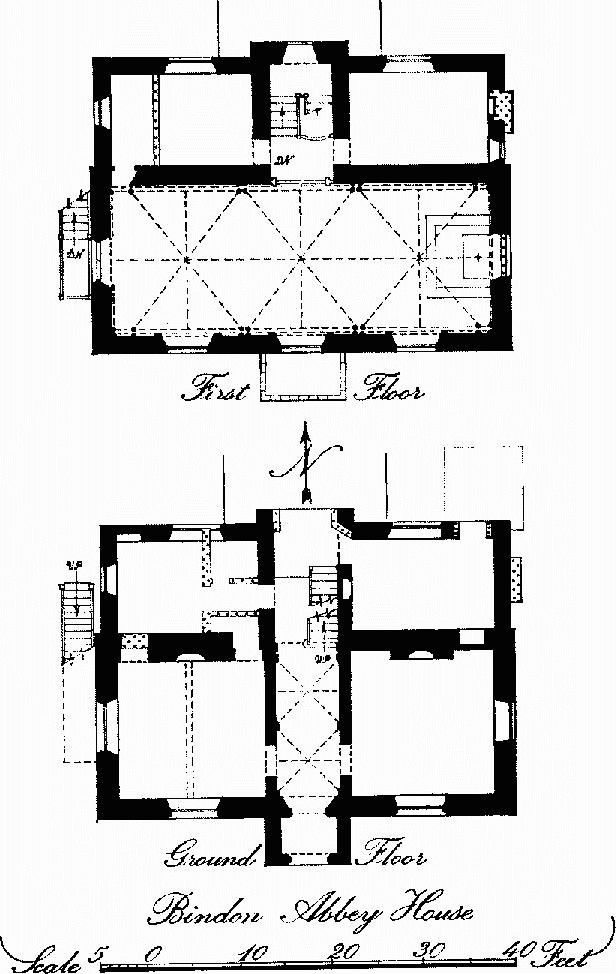
Bindon Abbey House
The house, built by a member of an old Roman Catholic family, must have been intended to provide a chapel, though not registered as a certified place of worship before 1852. It is thus a late 18th-century example of special-purpose planning of much interest(See also Lulworth, East, (2).) It contains delightful detail in the Gothic style.
Architectural Description—The main part of the house has a simple rectangular plan with a porch in the middle of the S. front and with gables to E. and W. On the N. side a projection slightly shorter than the main part is also of two storeys under a continuation of the N. roof slope. The S. porch has an embattled parapet with trefoiled panels in the merlons; the outer doorway has moulded stone jambs and continuous two-centred head under a moulded label with a similar moulding enclosing spandrel panels and a rectangular panel above; the panels contain quatrefoils and plain shields some of which retain traces of colour. To each side of the porch is a low window with hollow-chamfered stone dressings and label, divided by wooden mullions into four lights with pointed heads and small spandrel lights. On the first floor are three large windows with hollow-chamfered stone jambs and continuous two-centred heads with labels; each now has a wooden frame with two pointed lights; these frames are probably of 1893 as early sketches of the house show windows of three lights with tracery in the window-heads. The E. end is finished with a parapet surmounted by crocketed finials. Each floor has an opening with two-centred head formerly with three lights and tracery; the lower opening now contains modern french doors and the upper one is blocked; in the gable is a small arched recess. The W. end is generally similar to the E. but the ground floor has a square-headed window and the arched opening to the first floor is fitted with a modern door and is reached by an external timber staircase. The N. elevation is partly concealed by a modern addition; in the middle is a slight projection marking the position of the staircase and finished with a gable which has parapet and crocketed finials uniform with those to E. and W. To each side are low windows divided into four arched lights under timber lintels; the lower ones have the lights sub-divided; one has been lengthened and one retains the original glazing of small leaded quarries.
The plan provides a central entrance hall between two living rooms and leading to a staircase between two smaller rooms to the N. The inner entrance has a two-centred head and the door has cinque-foiled panels and traceried head. Similar doorways (Plate 202) lead to the principal rooms. The Hall has a plaster vaulted ceiling springing from corbels with painted shields-of-arms of Bindon and other abbeys. The Dining Room, to the W., has a fireplace-surround made up of various pieces of carved oak mostly of the 17th century. The original iron firegrate has panels with figures of Peace and Plenty. The Drawing Room to the E. also has an original iron firegrate. The Staircase (Plate 202) has square newels with sunk cusped panels and pyramidal finials. Over the staircase is a plaster vaulted ceiling.
On the first floor the doorways to the N. bedrooms have two-centred heads and doors with cusped panels similar to those already described. The whole of the S. part of the house now forms a Chapel (41 ft. by 16 ft.). It has a ribbed, plastervaulted ceiling springing from clustered columns with moulded caps and bases, all of 1794–8. The windows have moulded edges to the openings and moulded labels. These mouldings are repeated on the N. wall round the arched doorway and round matching panels to each side. Below the label stops are late 19th-century shields-of-arms of former owners of Bindon.
Gatehouse (Plate 201), 60 yds. S.W. of house, has rubble walls with brick dressings and embattled parapet. The W. elevation is divided into three bays by four buttresses rising to crocketed pinnacles. In the centre bay is a carriage entrance with brick two-centred arched head of five orders and in each side bay is a window with an arched head of three orders enclosing wooden casements in the Gothic style. The gates have cusped and traceried panels, similar in style to the doors in the house already described, and shields-of-arms of Cardinal Thomas Weld (1773—1837). The E. elevation is similar but has two buttresses only and one of the windows is replaced by a blind recess. The central carriageway is covered by a groined plaster vault. Rooms to each side include a living room, kitchen and attic bedrooms above.
Outbuilding, N. of the house, of one storey with rubble walls and modern roof, is of uncertain date. It appears in a sketch dated 1804. Original doorways and windows have been blocked. Ice-house, in mound surrounded by wet ditches (43), E. of abbey ruins, has a brick barrel vault and is contemporary with the house (Hutchins I, 353; Weld Estate Accounts, in D.C.R.O., first mention filling ice-houses 24 Dec. 1796).
Monuments (8–41)
Monuments (8–41) unless otherwise described are of two storeys with walls of rubble or cob and thatched roofs; they are of the late 18th or early 19th century. The cottages are generally built on a two-room plan with a central entrance.
a(8) Houses, two, one dated 1796, one of the early 19th century, with additions, form a single range.
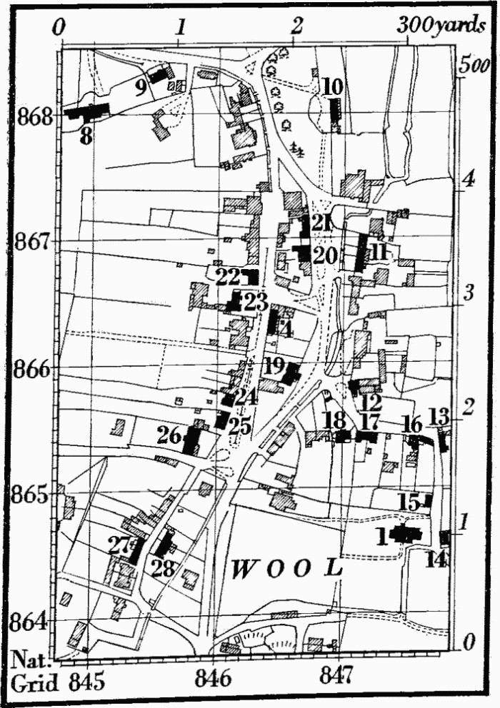
Wool
a(9) House, No. 3 Station Road, has brick walls and is of the 18th century, enlarged in the 19th.
a(10) Springfield Cottage has walls rendered in stucco and was originally two houses; bay windows and porches are modern additions.
a(11) Cottages, four, the two at the N. end opening off a common through passage.
a(12) House has segmental brick arches over the ground-floor windows.
a(13–17) Cottages.
a(18) Seaforth Cottage, with the upper storey partly in the roof, is designed in a self-consciously rustic style (Plate 42). The symmetrical front elevation has a central thatched porch supported by rough poles, french windows to each side and round-headed windows above, the central one having a brick label.
a(19) Barn has walls of rubble and brick and tiled roof with stone slates at the verges.
a(20) House has brick dressings and tiled roof; built into the walls are some fragments of moulded stonework of the 12th century.
a(21) Cottages, two, are of one storey and attic.
a(22) House is probably of the 18th century with a wing added in the 19th century.
a(23) House, probably of the early 18th century, is built on an L-shaped plan.
a(24) House has a slated roof.
a(25) House (Plate 46) has the front and end walls of brick and the back wall of cob. The date 1753 is cut in a brick at the N.E. corner, and the house has been lengthened to the S.

a(26) Collier's Barn has walls mainly of brick and tiled roof.
a(27, 28) Cottages.
b(29) Woodstreet Farm, house (856856), was built in the late 16th or early 17th century on a three-room plan and extended to the N. later in the 17th century; a W. wing was added in the 18th century.
The original house has a doorway in the W. wall with cambered stone lintel but all the windows have been renewed. An old newel stair at the side of the fireplace to the central room has been replaced by a later straight staircase; in the old N. room the exposed chamfered beams are carried on stone corbels; over the S. room part of a jointed upper cruck is exposed. The added N. room has in the W. wall the moulded label for a mullioned window, now destroyed, and in the N. wall a fireplace with four-centred timber head, the N. wall together with the flue of the chimney being of cob. Outbuilding, against S. end of house, of rubble and brick with tiled roof, is of the 18th century. Farm buildings, to W., include a Granary of the 18th century, a Barn re-roofed in the 19th century and a Barn of brick with buttressed walls of the early 18th century.
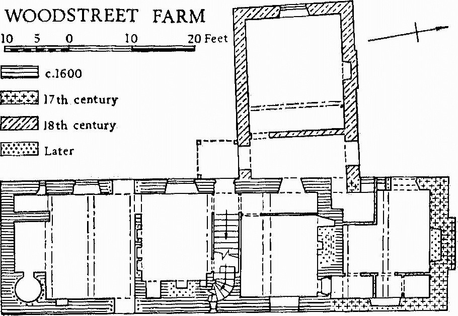
Woodstreet Farm
b(30) Barn, at Bindon Farm (854865), is of the mid 18th century.
a(31) Bovington Farm, house (827883), of two storeys and attic, has brick walls above a rubble plinth and is of the first half of the 18th century. On plan the house is T-shaped but the back wing has been rebuilt; the front block has been rearranged internally. An extension to the N. with a large open fireplace and oven is little later than the main building. The E. front has a plat-band at first-floor level, central entrance and double-hung sash windows under segmental arched heads with keystones.
East Burton
a(32) East Burton Dairy, house (831870), of one storey and attics and with brick walls, is of the early 19th century. Barn to W. is of the same date.
a(33) Burton Farm, house (833870), has brick walls and tiled roof and is of the early 19th century.
a(34) House (832870) was built on a three-room plan with end chimneys. It has been modernised and the centre part rearranged. The upper windows retain horizontal sliding sashes. Barn to N. is contemporary with the house.
Monuments (35—41), in E. Burton, were all built as cottages on a two-room plan with one end chimney and are mostly of the early 18th century. Some have the upper storey partly in the roof.
a(35) Cottage, at Giddy Green (831867), partly refaced in brick, has a stable or store with loft above at the N. end.
a(36) Cottage (831869) retained until recently original wood-framed windows with chamfered mullions.
a(37) Cottage (832869) has a modern iron roof and has been heightened.
a(38) Cottage (832869), E. of last, has been enlarged and much altered.
a(39) House (833870) has extensive additions to the original cottage.
a(40) House (832871) has been enlarged and modernised.
a(41) House (832870) has been enlarged.
Earthworks, Etc.
Mediaeval and Later Earthworks
a(42) Settlement Remains, formerly part of Wool village (849866), occur immediately E. of the present village where an area of 2 acres with closes lies on either side of a hollow-way running in from the W. This road was already blocked by a cottage in 1770. (Estate Map by J. Sparrow (1770), in D.C.R.O.; R.A.F. V.A.P. CPE/UK 1821 : 6416.)
b(43) Channels and Ponds at Bindon Abbey (854867) lie E. and S.W. of the Abbey ruins (3) and in meadows immediately W. and N.W.; the site is almost at river level and the channels serve a real need for drainage. Some may have originated before the Reformation as fish-ponds, but the majority probably owe most of their form to the garden of a private house which succeeded the monastery and was burned down c. 1644. In the late 18th century there was a thorough restoration of the site when the present house (7) was built; at this time the water-course was cut between the Abbey and Bindon Mill, just N. of it, apparently through part of the monastic cemetery (Hutchins I, 352–3).
There are two main enclosures formed by wet ditches. On the S.W. of the Abbey, ditches form a square of about 4/5 acre containing a central lozenge-shaped pond with a flat, circular island in the middle. The enclosing ditches are linked to this pond and crossed by causeways; the whole is thickly overgrown. E. of the Abbey is a rectangle of 2 acres bounded by a bank and a broad ditch crossed by a causeway on the W. In the centre a penannular ditch encloses an artificial mound, 87 ft. in diameter and 10 ft. high, in two stages with a walk around the base of each: this mound was probably built in the 16th or 17th century and restored in the late 18th century when a vaulted ice-house was inserted (see Monument 7).
In the meadow 250 yds. W. of the Abbey a bank, some 27 ft. across and 1½ ft. above a ditch on the W., runs N. and continues beyond the road from Wool; it then seems to have curved N.E. to join the Frome. This might be a monastic boundary and its ditch could also have supplied the ponds, though springs are the present source of water in the area. (J. Sparrow, 'A Plan of Woodstreet and Bindon Farms' (1770), in D.C.R.O.; W. part of estate plan (before 1775), in D.C.R.O.; plan in Hutchins I, opp. 353; for mounds as garden features, see M. Hadfield, Gardening in Britain (1960), 40–1.)
Other Earthworks and Allied Monuments
(44—49) Round Barrows, p. 473
(50,51) Roman Remains, p. 620


