Pages 177-184
A History of the County of Oxford: Volume 15, Bampton Hundred (Part Three). Originally published by Victoria County History, London, 2006.
This free content was digitised by double rekeying. All rights reserved.
In this section
MINSTER LOVELL
Minster Lovell, known by the early 19th century for the picturesque riverside ruins of its medieval manor house, (fn. 1) lies in the Windrush valley 2¾ miles (4½ km) north-west of Witney and 12¼ miles (19½ km) west of Oxford. (fn. 2) By the early 13th century the parish formed a detached part of Chadlington hundred, presumably reflecting early tenurial links; certainly in the 15th and 16th centuries Minster Lovell manor included holdings in Chadlington, Shorthampton, and Chilson, though no pre-Conquest connections have been traced. (fn. 3) The place name, recorded in 1086, derived probably from a late Anglo-Saxon minster on the site of the present church, and the suffix Lovell, from the chief landholding family, was added from the 13th century. (fn. 4) The ancient parish, 1,951 a. (789 ha.) in 1881, remained unaltered in 1991; (fn. 5) it included the small hamlet of Little Minster immediately west of Minster Lovell village, and in the late 1840s the new settlement of Charterville was established in the parish's southern part by the Chartist leader Feargus O'Connor.
Parish Boundaries and Landscape
The north-western boundary (fn. 6) follows the river Windrush and, further north, the contours of a steep-sided valley through former woodland; a short detour from the river's main course near Lower Field Farm placed a small area of riverside meadow in neighbouring Asthall. The sinuous northern boundary, roughly along the line of Akeman Street, formerly divided woodland coppices in Asthall from those in Minster Lovell. The eastern boundary, from Akeman Street to Charterville's southern edge, was described in the 10th and 11th centuries, when it formed the perimeter of the neighbouring estate of Witney; the short southern boundary follows a track called in the 19th century Minster Freeboard, which formerly demarcated the open fields of Minster Lovell and Brize Norton. (fn. 7)

60. Minster Lovell street, looking south-west to the Swan Inn
The parish is bisected almost symmetrically by the river Windrush which, particularly near the village and former manor house, divides into numerous small channels separating islands of meadow and pasture. The geology is complex, the parish lying chiefly on cornbrash and Forest Marble with, in the north, a small area of Boulder Clay within the former woodland, and across the middle a narrow band of alluvium. The land rises from around 85 m. in the valley bottom to nearly 140 m. in the north, and to 105 m. in the south; in places the river valley is steeply embanked, notably near Little Minster and Lower Field Farm, and another steeplyincised valley runs north—south near Ringwood Farm. (fn. 8)
Communications
The section of the Roman Akeman Street running through woodland roughly along the parish's northern boundary was disused by the 18th century and probably by the Middle Ages. (fn. 9) The main early route through the parish, recorded from the Middle Ages, was the Burford—Witney road, an ancient ridgeway which ran east-west, south of the village and river. (fn. 10) It was turnpiked in 1751 and disturnpiked in 1870; (fn. 11) a turnpike gate near the White Hart inn existed by 1767, and a two-storeyed toll house stood opposite the inn until demolished about 1956. (fn. 12) Another tollgate stood in the late 18th and early 19th century on the lane forming the parish's southern boundary, presumably to prevent travellers avoiding the main toll house since, at each end, the lane connected with the Burford road. (fn. 13) A stretch of the lane was also ancient, forming part of a road called Wood Street in 1044. (fn. 14)
From the early Middle Ages settlement lay to the north of the Burford—Witney route, along roads or tracks running eastwards to Crawley and Hailey, and connecting with others, probably also ancient, running north to Asthall Leigh, Fordwells, Field Assarts, and Leafield. The road to Crawley and Delly End (in Hailey), along which much of the modern village stands, connected probably with roads in Hailey's northern part recorded in 969, while Ridings Lane, along the eastern boundary with Crawley, led in the 10th century to Langley (in Shipton-under-Wychwood). (fn. 15) Minster Lane, mentioned in 1687, (fn. 16) was possibly the road to Little Minster.
The network of roads north of the river was linked with those to the south by a stone bridge, in existence by 1197; (fn. 17) probably it superseded a ford. From the bridge a road ran south-east past Windrush Farm to join the Burford-Witney road. Another road or track, again probably ancient, ran south-west to cross the same road at the location of the White Hart Inn, proceeding thence to Brize Norton.
Repairs to the bridge by local inhabitants were noted about 1587, and again following disputes over liability in 1843; (fn. 18) the existing structure, of three arches, appears to be post-medieval. (fn. 19) In 1547 the vicar left money for repairing highways, and in 1588 the manor court ordered repairs of the royal ways as required. (fn. 20)
Stage-coaches to South Wales passed through the parish until 1879, and there was a daily omnibus service between Burford and Witney in the late 19th and early 20th century. Carriers to Milton-under-Wychwood were noted until about 1924, and a carrier to Oxford was recorded in the 1890s and 1910s. (fn. 21) A post office was run from Locks Cottage at the north-east end of the village street between 1853 and 1938, the nearest money order and telegraph office being at Witney. Letters arrived at first through Witney and, after 1931, through Oxford. The post office moved in 1938 to Wenrisc Drive, part of new housing areas off Brize Norton road, and in 2004 belonged to a general store. (fn. 22)
Settlement, Topography, and Population
Settlement to 1086
Collections of Mesolithic, Neolithic, and Bronze-Age implements and pottery suggest prehistoric settlement, notably near Minster Riding, where over 4,000 Neolithic domestic artefacts were found. (fn. 23) Roman activity is suggested by pottery found north-west of the Curbridge boundary, and in the churchyard; (fn. 24) other finds include a brooch and fibula, and individual coins or hoards, dating from the 1st and 3rd centuries AD and from the time of an otherwise unknown local leader named Andocomius. (fn. 25) Of particular significance is a hoard of 24 sestertii of Claudius (c. AD 43) found on a site north of the medieval manor house; a smaller hoard was found at Charterville in the mid 19th century. (fn. 26)
Anglo-Saxon settlement along the Thames and Windrush valleys, with Minster as one of the peripheral sites, is well-attested from the 5th century. (fn. 27) Skeletons, goods, and a circular dwelling, of possibly 7th-century date, were found in the 1870s near Starveall Farm in the south-west, (fn. 28) and later excavations near the churchyard uncovered 5 postholes and 9 graves, undated but probably late Saxon. (fn. 29) By the 9th century Minster may have been the site not only of a pre-Conquest church with jurisdiction over the area between Shipton-underWychwood, Bampton, and Eynsham, with which such burials may have been associated, but also of a Mercian royal vill. Circumstantial evidence, besides the place name, includes the church's unusual dedication to the Mercian royal saint Cynehelm (St Kenelm), and the discovery before 1718 of a sumptuous gold and enamel mounted artefact of c. 900 known as the Minster Lovell Jewel, though firmer documentary or archaeological evidence is lacking. (fn. 30) Separate settlement around Little Minster, south of the river to the west, existed possibly by the mid 11th century, when it already formed a distinct estate; (fn. 31) the name Little Minster was recorded from the mid 13th century. (fn. 32)
Population from 1086
In 1086 a total of 29 tenant households was recorded, most of them on the chief manor, together with 4 slaves or servi. (fn. 33) By the late 13th century the population had risen sharply: there were then up to 50 households on Minster Lovell manor and at least 7 at Little Minster, a total population of 230 or more. (fn. 34) Around 25 taxpayers were assessed in the early 14th century. (fn. 35) Plague mortality in the mid 14th century seems to have been heavy: only 86 adults over 14 were mentioned in 1377, and in 1423 the number of villeins on the chief manor had fallen to 17, from 30 recorded in 1279. (fn. 36) The population seems to have remained below 13th-century levels in the early 16th century, when 18–20 landholders were taxed; up to 27 houses were noted in 1602, but only 18 were taxed in 1662, and in the 1640s and 1670s the adult population was around 100, roughly evenly divided between men and women. (fn. 37)
Throughout the 18th century baptisms consistently outnumbered burials, (fn. 38) the number of houses being estimated in 1738 at 25, in 1759 at 30–40, and in 1771 at 37; in 1801 the population was 283, a total of 57 families accommodated in 49 houses. (fn. 39) In 1821 it was 300, remaining fairly stable until Charterville's foundation in the 1840s: in 1851 it was 450 accommodated in 142 houses, and in 1861 it was 586. (fn. 40) Numbers gradually diminished between the 1870s and 1930s, returning to an average of 440–60, but by the 1950s the population was rising again, reaching over 700 by 1961. In 1991 it was 1,340, a total of 513 households. (fn. 41)
Village Topography and Development

61. Minster Lovell village, church, and manor house, c. 1919
Early medieval settlement may have been concentrated around the church and adjacent manor house, on the edge of gravel and Forest Marble close to the river (Figs 61, 69, and 71). Both the church and Manor Farm to its north, incorporating remains of the medieval chapel of St Cecilia, stand probably on the site of a pre-Conquest minster, and the manor house, though rebuilt in the 15th century, almost certainly occupies the site of an earlier house mentioned in 1197, which may itself have succeeded an 11th-century predecessor. (fn. 42) Pottery of the 13th century or earlier was found near the barns at Manor Farm. (fn. 43) The existing village lies further west along the Crawley road, though traces of medieval settlement, including crofts and house platforms, have been identified between the two sites by the river bank. (fn. 44) A suggestion that the modern village resulted from 17thor 18th-century replanning, perhaps by the Cokes as lords of the manor, is without supporting evidence; the village lacks the uniformity characteristic of planned estate-villages, while several existing buildings are of possibly earlier date, (fn. 45) and it seems more likely that the existing topography is the result of late medieval depopulation. A mill stood by the bridge at the modern village's west end by 1197, (fn. 46) and the base of a probably 15th-century stone cross survives to the north near the Swan hotel; (fn. 47) a house belonging in the Middle Ages to the so-called priory of Minster Lovell may have stood across the river. (fn. 48) Little Minster, with its irregular and scattered lay-out, similarly shows signs of shrinkage, the earliest surviving buildings being the 17th-century Cot Farm and Old Manor House, the latter possibly on or near the site of a medieval manor house. (fn. 49)
No other outlying medieval sites are known, though Windrush Farm, south of the river by the lane to the Burford road, existed by the 17th century, (fn. 50) and Whitehall (formerly Starveall) Farm, in former open fields in the south-west, existed by 1767, having presumably been built after inclosure during the 17th or the early 18th century. (fn. 51) Lower Field Farm, by the river near the western boundary, was established by the mid 19th century, and Ringwood Farm in the north was built around 1857 after clearance of the woodland which until then covered much of the parish's northern part. (fn. 52) Other new building during the 19th century was chiefly confined to the new settlement of Charterville, south of Minster Lovell village by the Brize Norton road, which is described below; the vicarage house on Church Lane was largely rebuilt in the 1850s, however, other new institutional buildings being the Wesleyan chapel (c. 1861) and National school (1872), both outside the main village, and a Primitive Methodist chapel (1893) in Charterville. (fn. 53)
There was little other new building in Minster Lovell before the 1950s, when infilling began in the south first on the lane to Bushy Ground Farm, then on the Brize Norton road between the Charterville cottages. Larger council estates followed in the angle between the Brize Norton and Burford roads. (fn. 54) By 1977 Lower Crescent had been established, and the west side of the Brize Norton road south of the former A40 trunk-road was heavily built up, including several closes of council housing built between the 1960s and the 1980s. (fn. 55) Such expansion resulted in the effective creation of a new and separate community in the parish, distinct from the historic village, and with its own institutional and commercial premises: St Kenelm's village hall opened in 1927, the post office on Wenrisc Drive in 1938, and St Kenelm's primary school after 1968, around which developed a small shopping area. (fn. 56) By contrast the old village saw relatively little change, though from the 1970s its social tone was altered by an influx of commuters working as far away as London, and of well-to-do retired people attracted by its proximity to the Cotswolds.
Until well into the 20th century the village was often muddy and sometimes flooded, especially around the church and churchyard, and in the early 20th century women still wore pattens to cross the village street. Several new drains were built after 1955. (fn. 57) The Wessex Electrical Co. was laying cables in 1938, and water and electricity were generally available by 1951; main drainage was provided in 1967–8. (fn. 58) In 1937 Witney Urban District Council constructed a new reservoir for the area, called Worsham, although it lay just within Minster Lovell parish. (fn. 59)
The Growth of Charterville

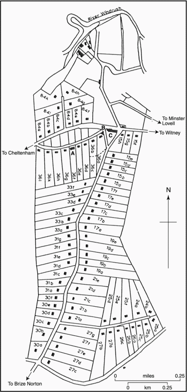
62. Charterville in 1851. (A. school and meeting house; B. Wesleyan Methodist chapel (by 1861); C. White Hart inn; numbers refer to the tithe award)
Charterville (Figs 62 and 64–5) originated soon after 1842, when Feargus O'Connor's National Land Company bought 244 a. adjoining the Brize Norton road from the executors of John Walker, a wealthy Minster Lovell farmer. (fn. 60) O'Connor, prominent in the Chartist movement from which the colony was named, hoped to take families away from factory-living or unemployment in towns and to set them up to be self-supporting on land in the country, thereby also giving them sufficient property to enable them to vote. The Minster Lovell estate was built by national subscription, land on both sides of the road and elsewhere, including Walker's homestead, being divided before 1847 into around 80 regular plots each comprising between 2 a. and 4 a. of arable and a small cottage. By 1848 some 73 of the plots had been filled, settlers coming from as far afield as Canterbury, London, and the northern manufacturing towns, though the experiment was at first unsuccessful because the allotments were too small to support a family, and the new tenants were not used to working on the land. By 1851–2 many of the original tenants had left, and the National Land Company itself was bankrupt and was later dissolved. Local farmers bought or rented the plots, often cultivating them in addition to other land, and Charterville became more prosperous towards the end of the 19th century. A visitor in 1861 described it as 'a large collection of cottages ... all inhabited by labourers and little farmers ... mostly exhibiting comfort, cleanliness and good order', and noted with evident approval both the presence of Nonconformist meetings and the absence of an alehouse. Other social facilities included a school, built by O'Connor at the settlement's inception. (fn. 61)

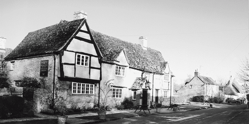
63. The Swan Inn from the south-west
Domestic Architecture
The oldest domestic buildings in the parish are the medieval manor house (Minster Lovell Hall) and the nearby Manor Farm, both described below. (fn. 62) Most houses in Minster Lovell village are of the 17th century or later, built of local limestone rubble in traditional vernacular style, and many retained thatched roofs in the early 21st century. (fn. 63) The earliest is probably the Swan hotel at the village's south-western end, exceptional in retaining a timber-framed cross-wing probably of the 16th century, with a jettied first floor. (fn. 64) Windrush Farm, south of the river, may also be of 16th-century origin, and on the ground floor has some re-used windows of the late 14th or early 15th centuries with traceried heads; on the first floor is a round-headed window possibly of the 12th century, both sets having perhaps been removed from Minster Lovell Hall. An additional bay was added to the back in the 17th century to create an L-plan, and the house was further extended in the early 19th and again in the 20th century. The house was perhaps used as a dower house by the Wheelers, lessees of Minster Lovell Hall and demesne farm in the 17th century, (fn. 65) to which date the barn also belongs.
Seventeenth- and 18th-century houses in the village include Locks, Causeway, Tullochs, and Lily Cottages, and the Old House, and the White Hart public house on the Burford road is also 18th-century. The Old Manor House, the largest house in Little Minster and, with the Hall and Manor Farm, one of only a few gentlemen's houses, is also described below. (fn. 66) Orchard House north of Church Lane, a large detached building in Arts-andCrafts style, was built in the early 20th century by Mrs de Sales La Terrière, and Dundon House was built in 1937–8, using materials from a dismantled 17th-century house in Fulbrook. (fn. 67)
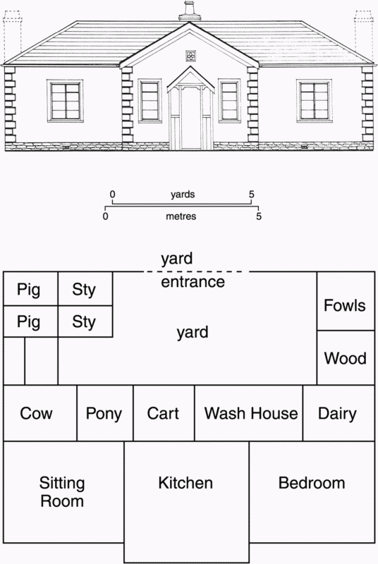
The Charterville cottages built under O'Connor's aegis, mostly detached and of uniform appearance, were 3-bayed single-storeyed dwellings of rendered stone rubble with slated hipped roofs, the central bay projecting forward (Fig. 64). The front part comprised 3 rooms for domestic use, each roughly 12 ft square; at the rear were service and agricultural rooms, including a scullery, dairy, hen house, pigsty, and wood store, with a privy and lean-to shelters for a cow and a pony and cart. (fn. 68) Most survived in the early 21st century, though often heavily altered. (fn. 69)
Social Life
Customs, Clubs, and Inns
Two friendly societies were founded, one in the 1800s, the other in 1843, but both had disappeared by 1856. (fn. 70) Clubs and societies in the early 21st century included the Women's Institute, founded in 1925, a Village Protection Society, a history society, and a social club. (fn. 71) A supposed Plough Monday tradition, of unknown antiquity, was recorded in the early 1950s, according to which any carter who, before the farmer could stop him, carried a piece of a plough to the farmhouse while reciting a particular verse acquired the right to a haycock, to be kept until May Day and used as a target for cockshy. (fn. 72) No confirmatory evidence has been found.

64. Charterville cottages: plan and elevation
Ale-sellers were mentioned in the 16th century. In 1753 there were two licensed houses, probably, as in 1786, the Swan in Minster Lovell village, and the White Hart on the Witney—Burford road. (fn. 73) In the 1930s the Swan became an hotel and restaurant, and in the early 21st century was run in connection with a conference centre established in the former mill nearby. (fn. 74) The White Hart remained open in 2004. The New Inn opened in the mid 19th century on Burford Road to serve Charterville.
Poor Relief
No parish charities are known, and poor relief was supported entirely from parish rates. The average levied from 1783 to 1785 was around £113, of which £100 or so was spent on the poor. (fn. 75) In 1776 all the money raised (about £80) was so spent, including rent for housing them and litigation costs. (fn. 76) As elsewhere, the cost of poor relief rose sharply in the early 19th century: in 1803 the parish levied around £489 at a rate of 7s. in the pound and spent £453 in all, £403 of it on the poor. A workhouse, not mentioned later, housed 14 people, who cost the parish £40 but brought in £104, presumably through sale of work; 57 children were also maintained, together with 3 disabled or ill inhabitants, but no other adults received out-relief. The following year poor relief was apparently subcontracted for £321. (fn. 77) Between 1813 and 1815 expenditure fell from £632 to £352, (fn. 78) the number on permanent out-relief falling from 10 to 7 and those on occasional relief from 25 to 23. Expenditure per head of population was broadly average for west Oxfordshire, except between 1813 and 1819 when it generally exceeded 45s. and once 50s.; (fn. 79) thereafter spending on the poor declined, falling from £506 in 1816 to £343 in 1834. (fn. 80)
After 1834 the parish became part of the newly established Witney poor-law union, to which responsibility for its poor passed; the vestry continued, however, to appoint overseers, and presumably oversaw rating. (fn. 81)
Education
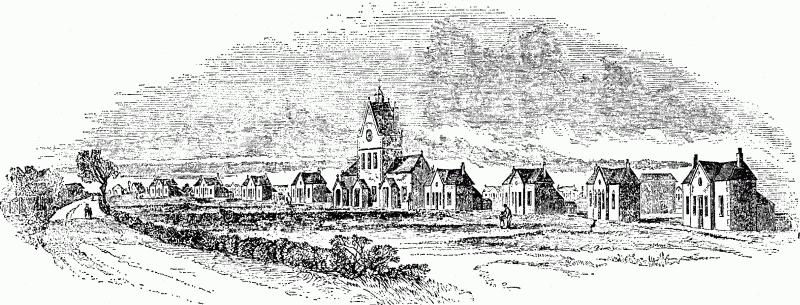
There was evidently no school in Minster Lovell in 1819, when the poor were said to want their children to be educated. (fn. 82) In 1835 a private school taught 20 children, paid for by their parents, (fn. 83) and a Sunday school had 60 pupils in 1854. (fn. 84) In 1868 there were two dame schools, each with around 12 children under 7 years of age, and a school for about 12 older boys who each paid 6d. a week, but there was thought to be need for a cheaper school in a central position. Feargus O'Connor had built a school in Charterville, though the inhabitants allegedly thought it inadequate (fn. 85) and it appears to have closed soon after, the building becoming a farmhouse.
Around 1871 a National school with accommodation for 94 was built in Little Minster, designed, in Gothic style, by William Wilkinson. (fn. 86) Lady Taunton gave the site as lady of the manor, the building cost met by subscription and by a government grant. (fn. 87) In 1875–6 accommodation was for 118 and average attendance was 77, the annual grant being £60 18s. (fn. 88) The school was enlarged to accommodate 140 children in 1899, and 145 in 1906. (fn. 89) In 1902 Joseph Abraham of Ringwood Farm, a Baptist not legally eligible to serve as a school manager, nevertheless acted as such, and was the most generous subscriber to the school; without his support a School Board would have been inevitable. (fn. 90) The school was allegedly overstaffed, with enough teachers for 185 children, although the roll in 1902 was only 79. (fn. 91)

65. Charterville in 1848, showing the school (with tower)
Numbers on the school roll fluctuated throughout the 20th century, from 110 in 1954 to only 71 in 1962. A new school building in Wenrisc Drive, in the newer part of the village, was opened in 1968, and the school had 131 pupils in 1970, falling to 71 by 1993; it remained open in 2001. The old building was sold in 1979. (fn. 92)


