Page 18
Survey of London: Volume 41, Brompton. Originally published by London County Council, London, 1983.
This free content was digitised by double rekeying and sponsored by English Heritage. All rights reserved.
In this section
Beaufort Gardens Development (p. 24)
a. Nos. 161-177 (odd) Brompton Road.

Beaufort Gardens development
Nos. 161-177 (odd) Brompton Road.
Drawing of development scheme by G. A. Burn, architect, 1860. Openings are shown to Brompton (formerly Lloyd's) Place on left, and to Beaufort Gardens (formerly Brompton Grove)
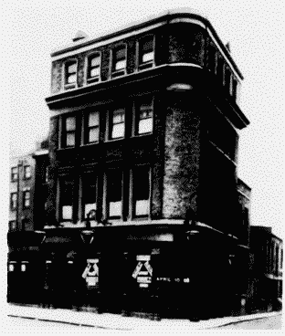
b. (above). The Red Lion, No. 161 Brompton Road 1903.

Beaufort Gardens development
(above). The Red Lion, No. 161 Brompton Road 1903.
G. A. Burn, architect, 1861.
c. (above right). Nos. 163-169 (odd) Brompton Road in 1960.

Beaufort Gardens development
(above right). Nos. 163-169 (odd) Brompton Road in 1960.
G. A. Burn, architect, 1861. Demolished
d. (right). Beaufort Gardens, east side in 1975.

Beaufort Gardens development
(right). Beaufort Gardens, east side in 1975. Jeremiah and Hanry Little, builders, 1861-70
Jeremiah and Henry Little, builders, 1861-70


