Pages 74-84
An Inventory of the Historical Monuments in the County of Cambridgeshire, Volume 2, North-East Cambridgeshire. Originally published by Her Majesty's Stationery Office, London, 1972.
This free content was digitised by double rekeying and sponsored by English Heritage. All rights reserved.
In this section
5 LODE
(O.S. 6 ins. aTL 56 N.W., bTL 56 S.W.)
(Fig. 71)
The parish, covering just over 3100 acres, was created in 1894 from the N.W. half of Bottisham parish. Apart from a narrow strip of lower chalk in the S., about 20 ft. above O.D., the land is mostly fen, 5 ft. to 12 ft. above O.D. Modern habitation is concentrated at Lode village and Long Meadow but the Hundred Rolls indicate medieval occupation N. of Long Meadow around Holmes plantation; all three centres may be regarded as early, secondary settlements of Bottisham.
Two large areas of fen were drained by the Adventurers in the mid 17th century; little further drainage was undertaken till the early 19th century following enclosure in 1808 and as a consequence outlying fenland farms were constructed. Lode village lies at the end of the formerly navigable canal, Bottisham Lode, which presumably predates the village and may be Roman in origin. The older houses, none of which is earlier than the 17th century, are mostly situated in the S. part of the village; in the N. the buildings are predominantly 19th-century and include dwellings which encroached on the green after its enclosure in 1808.
Ecclesiastical
b(1) Parish Church of St. James, built in 1853 by Rhode Hawkins, architect, at a cost of £1784.8.4 (Trinity College, MSS. box 28), possesses an Altar Frontal of embroidered silk depicting an altar and crowned monogram, Italian, 18th-century (Plate 65).
b(2) Baptist Chapel, of white brick with slated gabled roof, was built in 1832 (Gardner's Directory, 1851); later in the 19th century a two-storey porch incorporating a stair was added on the E. and a schoolroom and other rooms on the S. and W. On the E., shallow elliptical-headed recesses flank the porch which impinges against a triangular recess in the low-pitched gable. In the N. and S. side walls are sash windows separated by pilasters rising to an oversailing eaves course. A Register of Births starts in 1814 and a headstone in the burial ground is dated 1826.
Inside, against the W. wall is a high pulpit with bow front and reeded surround; attached are two tin funnels, possibly flower vases of the mid 19th century. The box pews have been rearranged and galleries on N., S. and E. are contemporary with the porch.
Secular
b(3) Anglesey Abbey (Fig. 72), consists of a house, outbuildings and grounds in a flat landscape adjacent to Lode village. The house of two storeys and attics is built of limestone and clunch rubble with 'Barnack' and other limestone dressings. The gabled roofs have modern tiles.
The buildings occupy the site of the hospital of St. Mary, probably a 12th-century foundation, which was endowed in c. 1212 by Richard de Clare, Earl of Gloucester, as a priory of Augustinian canons (V.C.H., Cambs. II, 229). The considerable benefaction of Master Laurence of St. Nicholas in the years immediately preceding his death in 1236 enabled much of the church, cloister, refectory, dormitory and prior's lodgings to be completed (P.R.O., Ancient Deeds A. 14494). The priory was dissolved in 1536 and three years later the estate was granted to John Hynde of Madingley. It passed to Sir Francis Hynde in 1550, at his death in 1595 to the Fowkes family, and hence to Thomas Hobson, the Cambridge carrier, Thomas Parker his son-in-law, Sir George Downing, Jacob John Whittingham, the Reverend George Jenyns, the Reverend John Hailstone and Lord Fairhaven. The Hyndes, being occupied with the building of Madingley Hall throughout the 16th century (R.C.H.M. Cambs. I, 179), undoubtedly neglected or dismantled much of the priory, but early in the 17th century those monastic buildings which still survived were altered for domestic use, possibly by John Fowkes. A service wing, subsequently altered or rebuilt, was added on the W. by Hailstone in the middle of the 19th century; between 1926 and 1958 a first-floor library, stone staircases and a picture gallery on the N., were introduced by Lord Fairhaven.
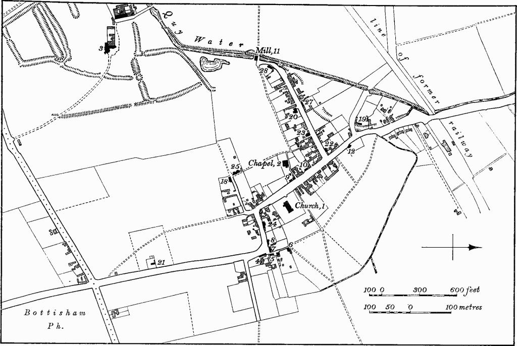
Fig. 71 Lode, Village Map
The N. range of the existing house may be identified as the prior's lodging referred to in the account of Master Laurence's endowments in c. 1236. The undercroft of that date survives but details on the upper floor suggest a refurbishing in the late 14th century. Ancillary buildings have not remained but architectural features, either existing or recorded pictorially before 1860, infer a principal entrance at the N. end of the W. wall, possibly with a porch having a subsidiary doorway on the S. through which rose a stairway to reach an upper doorway (C.A.S. watercolour by Relhan; E. Hailstone, C.A.S. 8vo. Publ. XIV (1873), Pl. opp. 153). The cut-back surface of the S. bay on the range's E. side implies either a vanished annexe which projected eastward or a much-rebuilt section between former buttresses. On the N. the springing of a barrel vault denotes a reredorter range. Post-medieval alterations to the S. range were extensive and interpretation can only be hypothetical, but visible evidence suggests a date contemporary with the N. range; it may perhaps be explained as a hall for prior or guests. The size of the windows, which had pointed heads, and the height of the buttresses together show that the range, at least at the E. end, was always of two storeys. Later alterations have obliterated the original arrangement of the W. part but in view of the length of the range subdivision would be expected. A doorway attributed to William Reche (Seggewyke), prior from 1515, appears to be reset and the range's domestic character is probably entirely early 17th-century.
A large roofless but hall-like structure, destroyed in 1861, summarily recorded by Hailstone (ibid. Pl. opp. 163), stood in an unrevealed position to the N. or W.; it contained a number of medieval features but its original purpose has not been ascertained. Hailstone also refers to moulded medieval fragments of masonry being found in the then kitchen garden which was probably S.W. of the house (ibid. 166 note). The site of the cloister may be inferred in that general area.
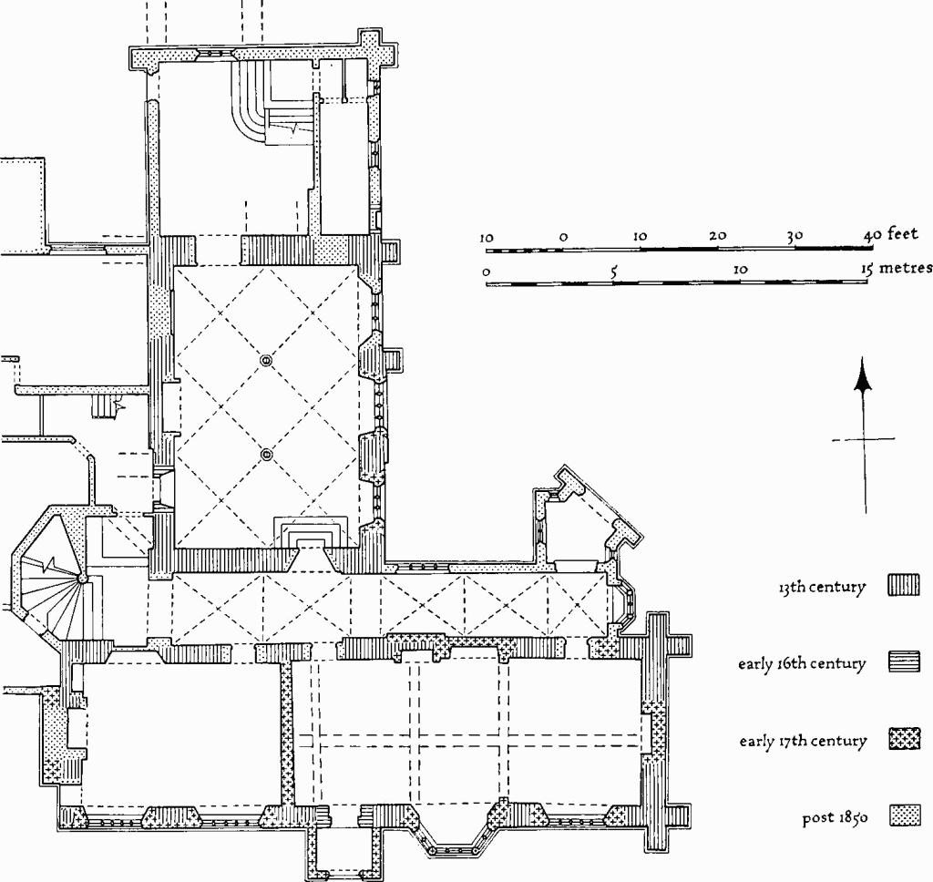
Fig. 72 Lode (3), Anglesey Abbey
The standing remains lie at the N. end of a large subrectangular area covering some 30 acres bounded by banks and ditches apparently marking the monastic precinct, within which fishponds and drainage ditches survive.
The mid 13th-century N. range (Plate 68), the assumed prior's lodging, is at right angles to the S. range and separated from it by a passage which is echoed externally on the E. by a recessed section of walling with three-light stone mullioned windows on the upper floors. The N. end of the range has been extended in modern times. The E. front is in three bays with two tall two-stage weathered buttresses of the 13th century, one at the original N.E. angle and one between the first and second bays. A jagged set-back of the wall face marks the S. bay and may reflect a former annexe to the E., or alternatively, removed buttresses. The N. and S. ground-floor windows each have three uncusped lights in four-centred heads and are set within the jambs and part of the springings of earlier openings, presumably of the 13th century; the N. window is modern but copies the S. which is perhaps 17th-century. The central window, also perhaps 17th-century, has four uncusped lights in a depressed two-centred head within the blocking of a 13th-century relieving arch with hacked-back label. The late 14th-century N. upper window has a four-centred head within two cinquefoil-headed lights, plain transom, continuous casement moulding and label with grotesque head stops; the four upper windows to the S. of varying numbers of lights with labels are 17th-century. The modern N. extension incorporates a small blocked late medieval doorway with four-centred head in the position of a former one, inconsistently recorded, beneath a single-pitched roof. This doorway originally opened into a barrel-vaulted passage of which the lower springing courses rise from a roll-moulded string-course in the N. face of the N. wall of the undercroft. Above the doorway a medieval window of two lights with pointed head is only original internally. The W. front is masked by a modern wing. At the S. end, four raking wall arches and one half-arch are set with the lowest to the S. (Fig. 73). The arches have triple roll-and-hollow mouldings, continuous roll-moulded label (Fig. 74), and are supported on five corbels with mask stops, much mutilated. The upper half-arch butts against the springing of a moulded rear-arch, at right angles. Below these springing-stones is the E. jamb of a chamfered and rebated doorway. A set-back above the arches is shown by Hailstone (ibid. 169) as a chamfered weathering. At the N. end of the W. wall, a first-floor doorway with a four-centred head is shown by Relhan in 1801 (C.A.S. watercolours) and Hailstone (ibid. Pl. opp. 153) together with the tusking of a N. wall of a structure returning at right angles. Inside (Plate 68), the range has an undercroft of three bays N. and S. and two bays E. and W. Octagonal piers of marble, possibly Alwalton, with limestone water-holding bases and moulded capitals, of the 13th century, entirely reworked or renewed, carry quadripartite vaulting with chamfered clunch ribs which are taken on triple-lobed wall corbels and singlelobed angle corbels carved as capitals and sub-capitals. The N. doorway is set within an arched and moulded recess which until 1939 formed an embrasure to a three-light window uniform with those in the E. wall, and probably the window reset in the present N. wall of the range. In the N. bay on the W. is a chamfered recess with pointed-segmental head, the survival of an opening shown by Hailstone (ibid. Pl. opp. 153) and possibly the original entrance to the undercroft; in the S. bay, a much-restored doorway with depressed four-centred head with spandrels carved with initials 'P W' and 'R', apparently for William Reche (Seggewyke), prior from 1515, and shield of Clare (three chevrons), both against foliage and branch backgrounds, is reset from a first-floor room (Hailstone, ibid. 168–9). On first floor, in original N. wall, is a late 14th-century doorway, with two-centred moulded head, continuous mouldings, lower part of jambs chamfered, and splayed jambs on the N.
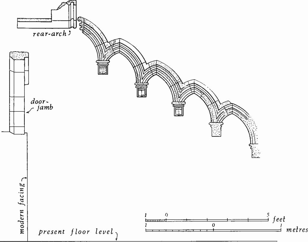
Fig. 73 Lode (3), Anglesey Abbey
Wall arches
The S. range (Plate 69), always of two storeys as demonstrated by the level of the original windows, may be mid 13th-century. It has a chamfered plinth and modern reproduction flush dormers based broadly on those shown by Relhan in 1801 which had been removed in the mid 19th century; the parapets of the main gables are modern additions. Early 17th-century alterations included the lowering of the upper floor and the insertion of new fenestration. The S. front of five bays is composed of varying masonry. The central two-storey porch, which does not bond with the main wall, has a round-headed doorway with continuous moulded head, lower part of jambs chamfered, renewed jewelled keystone, plain raised spandrels, classical string-course on front only, five-light mullioned and transomed window on the first floor and modern windows on the return sides. Over the doorway is a reset stone figure holding crozier, with mermaid at foot issuing from a circlet above a shield displaying a bunch of grapes, possibly medieval and foreign. The porch has modern strapwork parapet-cresting flanking a mounted figure of St. George and the Dragon, in Coade or artificial stone, perhaps late 18th-century; the flanking mullioned and transomed windows have five lights with relieving arches. To the E. is a two-storey semi-octagonal flat-roofed oriel with three-light mullioned and transomed window in the centre and two-light windows at the sides. At the N.E. and S.E. corners are tall two-stage weathered angle buttresses. In the E. bay on the S., the E. jamb and part of the springing of a pointed window rise from a string-course now hacked back, below the sills of the present windows. The gable-end chimney stacks have stone bases and modern brick shafts. The E. gable wall is mostly clunch, in blocks of two sizes, with a chamfered plinth. In the centre, small clunch blocks form the infilling of a pointed window, of which the jambs, hacked-back label and N. springing survive. Above, is a small 17th-century two-light mullioned window. The N. front is partly masked by ground-floor additions, but in the E. bay, the E. jamb of a window survives and is, with those on the E. and S., presumably of mid 13th-century origin. The N. front has two upper four-light mullioned and transomed windows of the early 17th century with labels and relieving arches, and two flush dormers with gable parapets. A nearly-flush chimney stack rises to a rectangular base carrying modern brick shafts; a projecting stack in the W. gable wall is probably 17th-century. Inside, the S. range now consists of two rooms but the E. was once divided. The 17th-century ceiling beams are intersecting and although the cross beams are modern that on the E. is in the position of the removed cross-wall; the beams have ovolo-mouldings and shaped stops, many of which are replacements. The doorway to the S. porch is much renewed, and the depressed four-centred head reversed so that the original head and spandrel is now on the N. with a modern replica on the S. The spandrels are carved with the initials 'p w' and 'R' for William Reche (Seggewyke), prior from 1515, and arms of Clare (three chevrons) impaling Burgh (a cross), against foliated background. The two-stage limestone fireplace, of c. 1600, is imported; it has debased Ionic pilasters, gadrooned panels and an unidentified shield of arms (a bend sinister). The first-floor rooms have chamfered axial ceiling beams with roll-and-hollow stops. At the E. and W. ends are 17th-century off-centre clunch fireplaces with depressed Tudor heads, continuous mouldings, shaped stops and foliated spandrels. The 17th-century roof has a double row of staggered purlins and mid-height collars. Scratchings on mullions of N. dormers include masons' marks, initials and dates, the earliest being 1650; on N.E. buttress is a scratched circle with compass-arcs, possibly medieval.
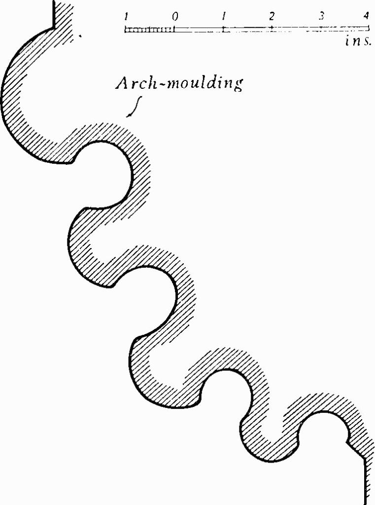
Fig. 74 Lode (3), Anglesey Abbey
Moulding of wall arches
Miscellaneous objects include: (1), at W. end of service wing, doorway with some early stonework, said to be reset from Ramsey Abbey, probably 13th-century; (2), in garden, two coffins with head recesses, three coffin lids, two with omega ornament, one with bracketed cross, and a fragment of a lid, all 13th-century; (3), in garden wall, opening with round-headed oak door with raised battens, central oval in square device, initials 'H C' in ironwork, said to be from Biggin House, Ramsey, late 16th-century (R.C.H.M., Hunts. 208, Pl. 160); (4), N. of house, loose fragments of moulded stonework, medieval; (5), W. of house, against courtyard wall, buttress of two weathered stages, date unknown; (6), reset in parapet of W. stair turret, three animal-gargoyles, late medieval.
The modern gardens and avenues are extensively furnished with statuary and urnage. The provenance or authorship of the following have been verified: 'Narcissus', marble, signed 'W. Theed fecit Roma 1848'; six caryatids, signed 'Coade, Lambeth, 1793'; 'Apollo', marble, from Gordon Castle, signed 'F. Harwood fecit 1765'; 'Diana and Actaeon', lead, from Copped Hall, Essex, signed 'John Cheere 1720' (Plate 118); four lead statues (Plate 120), corner acroteria from the Temple of Concord and Victory, Stowe House, Buckinghamshire, c. 1748–63; four marble vases (Plate 119) from Wanstead House, Essex, two by P. Scheemakers (1691–1781), one carved with sacrifice of Iphigenia (after the Medici vase in Uffizi Gallery), the second with sacrifice of Apollo, and two carved with Bacchanalian and heroic scenes by Laurent Delvaux (1696–1778) (R. Gunnis, Dictionary of British Sculptors, 126, 343, giving Wanstead House sale prices in 1822); three pairs of bronze urns from Bagatelle by Claude Ballin (1617–75); lead urn depicting a Bacchanal from Drakelowe Hall, Burton-onTrent, now mounted on drum-pedestal carved with garlands and figures, Roman, Continental (Plate 118); pair of stone obelisks from Copped Hall, 18th-century; ten stone columns with Corinthian capitals from Chesterfield House, 1748–9. Sources and authorship of the following objects have not been verified: two stone statues representing 'Gardening' and 'Fishing', dated1752, from The Hill, Hampstead; two vases from Canford, possibly French; large porphyry urn from Doughty House, Richmond; two bronze vases from Campsea Ashe, Suffolk, possibly French; twelve stone busts of Roman emperors from Headley Court, Walton-on-the-Hill, Dorking; 'Diana and the stag', bronze, from Ashton Manor, Exeter; 'Samson slaying Philistine', stone, by van Nost the elder; 'Apollo' and 'Diana', lead, style of Cheere, from Copped Hall; 'Apollo', marble, from Ashridge, Hertfordshire; pair of stone griffins from Park Close; 'Father Time', stone, style of Rysbrack; 'Father Time' with sundial, stone, from Stowe House; pair of lead lions, by van Nost the elder; pair of large stone urns from Stafford House, possibly French, 18th-century; 'Shepherd and Shepherdess', lead, style of Cheere, from Copped Hall; 'Apollo', sleeping, bronze, cast by Barbedienne. Also in the grounds or kitchen garden are: 'Hercules and Antaeus', stone, 18th-century; pair of lead sphinxes, 18th-century; large stone urn, 18th-century; vase in Coade stone; 'Minerva', lead, style of Cheere; marble copy of Uffizi 'Apollo', 18th-century; 'Shepherdess', lead, style of Cheere; a pair of terms with figures of Pan, perhaps 18th-century, Continental. (Connoisseur, CXIII, (1949), 88; Country Life (1954), 770, 860; Lanning Roper, The Gardens of Anglesey Abbey (1964))
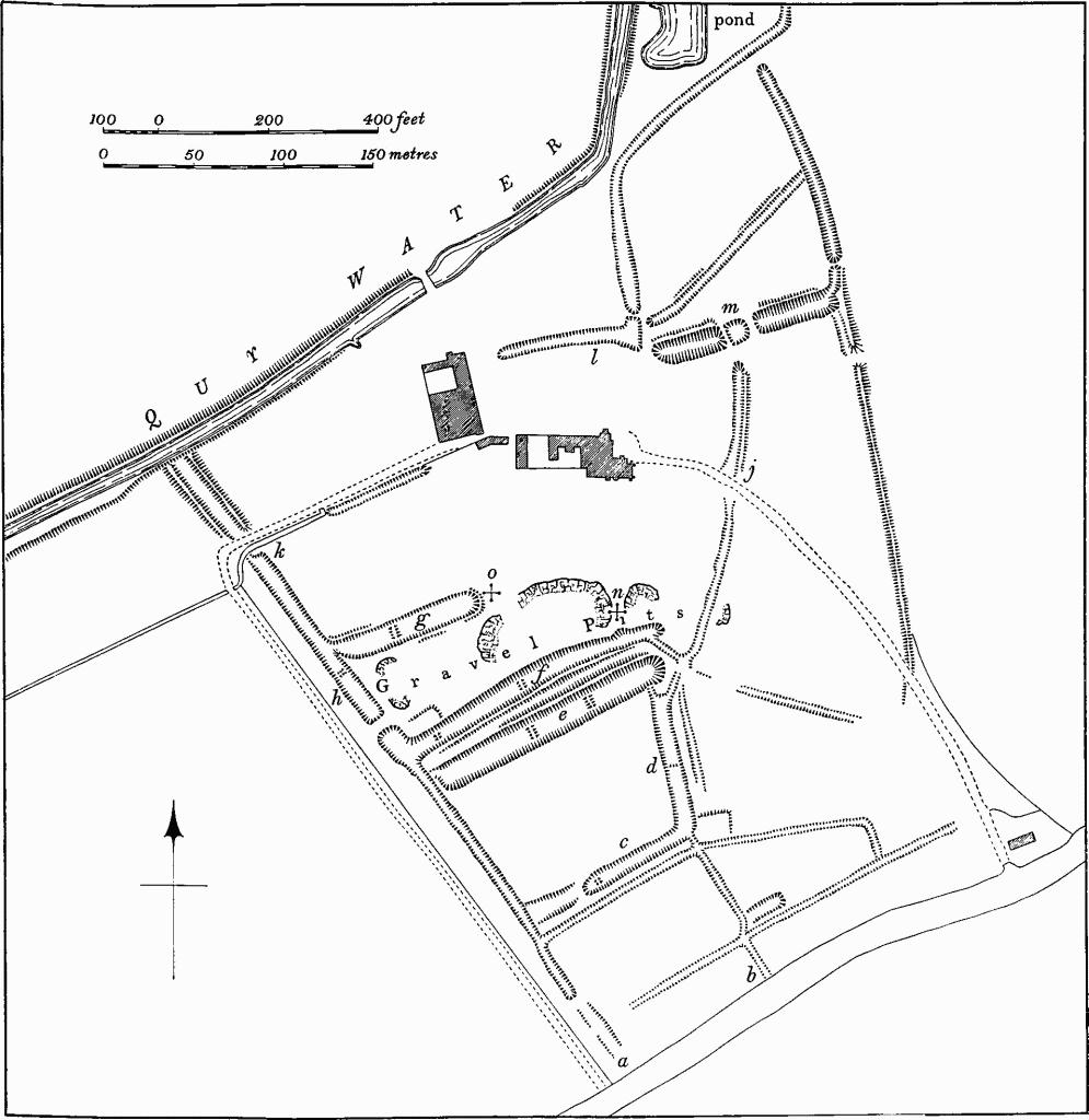
Fig. 75 Lode (3), Anglesey Abbey
Earthworks a and b: inlet channels. c to h: fishponds. j, k, l: outlet channels. m: pond.
Entrance gates, rusticated piers with lion finials, subsidiary side piers and wooden doors, from Admiralty Entrance, Port of London Authority, early 19th-century re-erected 1926.
Barn, N.W. of house, originally framed, has been reconstructed with a modern masonry E. wall. Original features include posts, tie beams, crown posts and braces to collar purlin; perhaps 16th-century.
Associated Earthworks (Fig. 75). The site of the priory and the extant remains are surrounded by a complex of ditches, ponds, banks and quarry pits not all of which can be interpreted. Many, and especially those in the region of the house, have been mutilated by garden landscaping, but their purpose can be broadly conjectured.
Most of the ditches appear to have been used to carry water to and from fishponds (Plate 69) and the priory buildings. The source of water was a stream flowing N.W. from Bottisham. This was diverted as it crossed Colliers Lane (around TL 527615) and entered the priory precinct at (a) and (b) on plan. The water then flowed through various ditches filling a series of fishponds (c—h) and continued either N. past the E. end of the priory (j) or N.W. to (k). At the latter point the stream divided, the surplus water running N.W. and apparently crossing the line of the present Quy Water; the second branch turned N.E. towards the priory, presumably passing under or round the buildings and emptying into a ditch (1) to the N. From here the water flowed either N. through two sets of ditches, or through a long wide pond (m) into which ditch (j) also emptied, and thence northwards towards Lode village. Pond (m) is now divided into three.
Most of the ditches are up to 20 ft. wide and usually only 2 ft. to 3 ft. deep where not recut. The fishponds, one up to 5 ft. deep, have low cross-banks within them, marking former divisions. Some of these cross-banks have slight depressions in their centres which are probably the sites of sluices (Plate 69).
S. of the house is an area of uneven ground, the result of quarrying stone rubble for roads in the early part of this century. During this work the stone footings of a small rectangular building are alleged to have been discovered at (n). Approximately at (o) two medieval coffins were found in 1857 (O.S. 25-inch map). (See Miscellaneous objects (2) above)
b(4) House (Plate 105), now a pair of Class-S dwellings, of one storey and attics, framed and plastered, with thatched gabled roof, is 17th-century. The stack has a recess for panel. The two N. rooms have stopped-chamfered axial beams and the two S. rooms each have cross beams, one of which is stop-chamfered; the partial rebuilding of the S. half of the house is implied. At the foot of the stairs is a 17th-century plank door.
b(5) House, of one storey and attics, framed and plastered, with thatched roof gabled on the N. and hipped on the S., was built in the 18th century on a Class-G plan. It now has a Class-S plan, the N. section having been rebuilt as a separate tenement in the 19th century. In the main room is a chamfered axial beam with wave stops; the smaller room, once a shop, has wooden lattice window on the W.
b(6) House, of one storey and attics, framed and plastered, clay-bat E. gable wall, with pantiled gabled roof formerly thatched, was built in the early 19th century. The plan is now Class-S, with the W. end divided axially, but a room may once have existed on the E.
b(7) House (Plate 105), of one storey and attics, framed, partly plastered and partly weather-boarded, with thatched gabled roof, is now a pair of Class-S dwellings but has possibly a 17th-century Class-J origin. The central stack has two shafts diagonally-placed with a small diagonal fillet between.
b(8) House (Plate 105), of one storey and attics, framed and plastered, with thatched gabled roof, originally Class G or J of the 18th century. To the chimney stack was added a flue for the end room in c. 1800.
b(9) House, now two dwellings, of two storeys, framed and plastered, with thatched gabled roof, perhaps originated on a Class-J plan in the late 17th or early 18th century. The small S. room with attic may be an early 19th-century addition; extensively modernized. (Access refused)
b(10) House, originally Class G or J, of one storeys and attics, framed and plastered, partly rebuilt in brick, with thatched gabled roof, was built in the late 17th century. Early in the 19th century the S. room became a separate dwelling. Inside, each room has an axial stop-chamfered beam. (Demolished 1969)
b(11) Watermill, of two storeys and loft, timber-framed, with modern vertical cladding over earlier weather-boarding, plain-tiled and gabled roof, was built in the early 19th century. Sluices, originally in white brick were later altered in red brick; at least 4100 bricks were used in building operations by H. and C. Giblin in November 1841 (Ledger in Lordship Farm, Swaffham Bulbeck (17)). It contains a broad iron water-wheel and machinery of the 19th century.
b(12) House, of two storeys, white brick with slated roof, is early 19th-century. Built on Class-S plan with symmetrical front it was soon converted to Class T by addition of an end stack.
b(13) House (TL 52676312), a pair of Class-S dwellings, of two storeys, clay bat with brick front wall, pantiled gabled roof, was built beside a fenland droveway in the second quarter of the 19th century.
b(14) Houses (TL 54486285), of one storey and attics, framed, partly replaced in brick, have gabled roofs originally thatched. The N. house was built in the late 18th century on Class-G plan, and early in the 19th century a Class-I house was added on the S. A rough chamfered axial beam survives in the central room of the first house. (Access refused)
b(15) Cranney Hall (TL 53496366; Fig. 3), Class-J, of two storeys, timber-frame with clay infill, weather-boarded and pantiled gabled roof, was built shortly after enclosure in 1808. The windows have sliding sashes. The N. end room is a very narrow pantry.
a(16) Fen Farm (TL 51606528), includes a Class-G or J house of one storey and attics, framed and plastered, with pantiled gabled roof, which was built 1808–11 (Enclosure Map; B.M., O.S. 2-inch drawings). Of two reused axial beams, that in the end room has folded-ribbon carving and was originally an intersecting beam of the 16th century.
a(17) Lode Farm (TL 52176711), of two storeys, white brick and slated hipped roof, was built soon after enclosure in 1808. It has an L-shaped plan; two service rooms in the rear wing were possibly dairies and had floors below ground level. The upper floor was partially reconstructed and new joinery introduced in the late 19th century.
b(18), b(19) Houses, Class G, of one storey and attics, gabled and timber-framed, 17th-and 18th-centuries.
b(20) House, Class I, of one storey and attics, timber-framed and plastered; possibly 17th-century.
b(21), b(22), b(23) Houses, Class S, first half of 19th century. (21) and (22) are of one storey and attics, timber-framed, with thatched gabled roofs (Fig. 3; Plate III). (23) is of two storeys, clay bat with pantiled roof.
b(24), b(25), b(26) Houses, pairs of Class-S dwellings, of one storey and attics, timber-framed partly brick-cased, are early 19th-century; (24) is entirely brick-built. (26) is at TL 54516278.
b(27), b(28) Houses, Class T, are early 19th-century. (27), of two storeys and cellar, pink brick, with slated gabled roof, was formerly an inn. (28), of one storey and attics, formerly plaintiled, now pantiled, is timber-framed faced in white brick.
a(29) Lock (TL 51656513; Plate 117), of 'flash' type, on Bottisham Lode, has white brick retaining walls, floor paved with stone flags, timber gate with cast-iron fittings and hoisting equipment. It was built in 1875 by J. A. Smith of Thetford at a cost of £294 (Swaffham I.D.B. Minutes, March and Sept. 1875). The walls are 11 ft. 9 ins. apart, 22 ft. long and splay at the ends. The gate-raising mechanism consists of a winding drum with ratchetted cogwheels in a braced timber frame; it had a large manually-operated winding wheel. (Timber demolished in 1968)
Earthworks
Roman
a(30) Roman Buildings (TL 54006325), lie 400 yds. W.S.W. of Grange Farm, on chalk marl at 15 ft. above O.D. The site, covering about 2 acres, consists of at least four rectangular patches of white earth visible after ploughing; each measures up to 30 ft. long and 15 ft. wide, and is associated with limestone rubble, roofing and box tiles, window glass and pottery. Between the white patches are small areas in which large quantities of pottery and lumps of grass-marked baked clay were found. The pottery appears to be mainly 3rd- and 4th-century, and includes Nene Valley types and some Horningsea wares.
Medieval and later
For earthworks at Anglesey Abbey see (3) above.
b(31) Possible Saxon burial (around TL 530622). A plain urn of Anglo-Saxon type was found at Anglesey Abbey in 1887. It may be the remains of a cremation burial (C.M.; Fox, A.C.R., 263).
ab(32) Bottisham Lode (Plate 6), first recorded by name in 1729 (Rot. Hund. II (1818), 484), certainly existed by the late 12th century (Reaney, 'Place-names of Cambs.', 131) although it is evidently much earlier (see p. lv). It is an artificial watercourse, some 2¼ miles long, extending in a N.W. direction across the fens from Lode village (TL 53206285) to the River Cam (TL 51026581). Nothing is known of its date of construction but by analogy with Reach Lode (see Swaffham Prior (74)) it is probably Roman in origin. Only in the 19th century is there much indication of its use for water transport; it is recorded in the 19th century that the Lode was inadequate for the larger fen lighters (Swaffham I.D.B. Minutes). It is considerably narrower than other lodes in the area.
Apart from a distinct southward bend just N. of Lode village, its general alignment is straight, though in detail all except the N.W. third is sinuous. The section between Vicarage Farm (TL 51646516) and the River Cam is straight and has been re-cut on a new alignment at some time before the late 18th century, and probably before 1673 (C.R.O., B.L.C. Petitions). The original winding course is marked by a ditch and the parish boundary, immediately to the S.W., called the 'Old Lode' in the late 18th century (Map of Bottisham parish c. 1790, St. Bartholomew's Hospital records).
At its S. end the Lode terminates in a wide triangular depression some 4 ft. deep, possibly the site of a former basin and wharf. Beyond it to the S.W. is a straight cut leading to the outfall of Lode Mill (11) which marks the end of Quy Water (Stow cum Quy (26)), and which feeds the Lode. However, there are indications that this straight section is a secondary feature, for the existence of low scarps suggests that the Lode once extended further S. and then turned S.W. across the former green to meet Quy Water at Lode Mill.
The Lode which has constantly been cleaned out and altered, now consists of a deep channel up to 22 ft. wide with high retaining banks on both sides (C.R.O., B.L.C. R59/31/9/ 12 and 11/1).
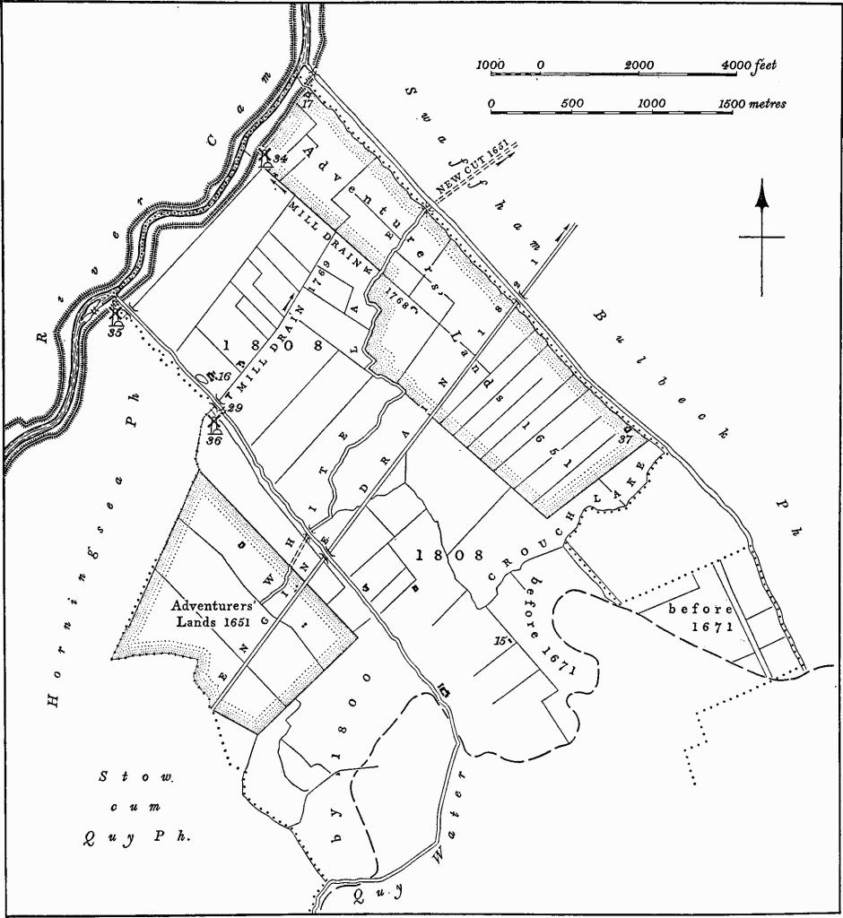
Fig. 76 Lode (33), Fen Drainage
Immediately W. of Fen Farm (TL 51556528) at the point where the Lode cuts through the N.E. end of a long ridge of gault clay, the retaining banks widen out to form a semicircular area of about 3 acres which has a series of ponds within it, N.E. of the Lode. The ponds were the result of excavating clay used in the repair of banks of the lodes and the River Cam from 1845 onwards (Swaffham I.D.B. Minutes, December 1845).
A lock (29), remains towards the N.W. end of the Lode.
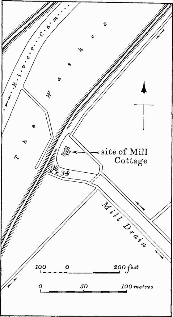
Fig. 77 Lode (34), Site of windpump
(33) Fen drainage (Fig. 76). There is no evidence of drainage systems being constructed in the parish during the medieval or earlier periods; Bottisham Lode, which is probably of Roman date, was not initially for drainage purposes. The earliest work resulted from the allotment of two areas of fen to the Adventurers in 1637 (C.R.O., R59/31/9/1A). These areas, known as Adventurers' Lands, consisted of 351 acres in the N.E. (centred TL 530660) and 300 acres in the S.W. (centred TL 518638); each was allocated in three lots. Enclosing and draining was probably started in 1651, when it was ordered that subsidiary allotments should be separated by tenfoot ditches (C.R.O., R59/31/9/5), and completed in 1655–6 (C.R.O., R59/31/9/6). Both areas were originally drained by two existing streams known as Crouch Lake and White Lake (C.R.O., R59/31/11/1) which were cleaned out and altered. Crouch Lake flowed to the S. of the N.E. block of Adventurers' Lands into Swaffham Bulbeck parish; White Lake, which was 12 ft. wide, flowed from the S.W. block (TL 52116413) under Bottisham Lode in a tunnel 2 ft. wide and 1 ft. high, across the N.E. block (TL 52806615), through Swaffham Bulbeck and Swaffham Prior parishes in a new cut, and thence to Upware (C.R.O., R59/31/9/5). The Bedford Level Corporation was responsible for this drainage until 1767 and their records show that these drains were frequently cleaned out and scoured, e.g. in 1717 (C.R.O., R59/31/10/13), in 1731 (C.R.O., R59/31/10/7) and subsequently.
Before 1700 parts of the fenland N. of Lode village and N.E. of Long Meadow were enclosed and drained, being described in 1671–2 as 'Fen ground lately enclosed by Thomas Parker out of the fen' (St. Bartholomew's Hospital records, Box 11). By 1709 Lode Moor of 11 acres was enclosed and drained; by 1800 a further 200 acres of fenland, N.W. of Lode village, was reclaimed (C.R.O., Map of Swaffham and Bottisham Fens, 1800).
By Act of 1767 responsibility for drainage passed to the Swaffham and Bottisham Drainage Commissioners who were obliged to reorganise the system owing to the sinking of the ground level. The White and Crouch Lake streams were abandoned as major drains and replaced by the newly-cut Mill Drain, which cut across the fen between Bottisham Lode and the Swaffham Bulbeck parish boundary. The new drain led to Bottisham Mill (34), a windpump standing on the edge of the River Cam. Shortly afterwards the drainage of the land S.W. of Bottisham Lode was linked to the revised scheme by cutting another Mill Drain from the W. corner of Adventurers' Lands (TL 51536472), under the Lode, alongside the present Lug Fen Droveway (TL 51656515–52386620), to meet the earlier Mill Drain (C.R.O., Map of Swaffham and Bottisham Fens, 1800; Swaffham I.D.B. Minutes, 1767 and 1768). In 1808 the remaining common fenland was enclosed (C.R.O., Enclosure Act and Award) and the new fields were delineated by ditches.
The single windpump proved insufficient to deal with the drainage of an area increased by the new enclosures and complaints resulted, especially in respect of the land S.W. of Bottisham Lode (C.R.O., Swaffham I.D.B. Minutes, 1792– 1820). The installation of a privately-owned windpump near the N.W. end of Bottisham Lode in 1821–2 (35), and of a steam engine with an Engine Drain which was cut across the parish (TL 51616324–53516576) in the same year, was only partly effective. In 1830 the Drainage Commission therefore erected another windpump on Bottisham Lode, known as Horningsea Mill (36). Fen drainage in the parish was finally achieved in 1850 with the construction of a new steam engine with its Engine Drain, in Swaffham Prior.
The stages of reclamation of Bottisham Fen are traceable on the ground. The two rectilinear blocks of Adventurers' Lands, enclosed by continuous drains, contrast with the patchwork layout of the areas drained subsequently.
a(34) Site of Windpump (TL 51886665), at the N.W. end of Mill Drove, consists of an irregular mound 30 ft. in diam. and 2 ft. high standing against the river flood bank (Fig. 77). Drains leading to and from the site are traceable. These features are remains of Bottisham Mill, erected in 1768 by the Swaffham and Bottisham Drainage Commission in order to drain Bottisham Fen (Swaffham I.D.B. Minutes, July 1767– Oct. 1768). Soon after its construction it was also made to drain land S.W. of Bottisham Lode by way of a tunnel under the Lode and by a channel called Mill Drain alongside Lug Fen Droveway (ibid., Oct. 1768–April 1769); this was unsuccessful, resulting in complaints from 1792 onwards of the inadequate drainage of fenland in Horningsea. The Swaffham Drainage Commissioners were unable to improve the system due to financial difficulties, and in 1821–2 landowners in Horningsea installed independently a windpump (35) to drain the area S.W. of Bottisham Lode. The pump of 1768 was burnt down and rebuilt in 1800 (ibid., July 1800); it continued in use for another forty years and was demolished in 1850 when the Steam Engine (Swaffham Prior (78)) was erected.
a(35) Site of Windpump (TL 51086571), S.W. of Bottisham Lode near the junction with the River Cam, is indicated by a rectangular pond partly in Horningsea parish (Plate 11). The pond, 100 ft. by 35 ft., is connected with drainage ditches at its S.W. end and served as a reservoir. At the N.E. end are two modern culverts carrying the water under the Lode. A windpump on this site was built in 1821–2 by Horningsea landowners to drain land S.W. of Bottisham Lode after the pump (34) erected by the Swaffham Drainage Commissioners had proved inadequate. It was described as the 'Fan Tail Mill' on account of the device, unusual in windpumps, which enabled the direction of the sails to be maintained correctly without supervision; as the pump was privately-owned the dispensing with a miller may have been a consideration. The pump, which was probably abandoned in 1845, was finally removed in 1849, the materials being used in the building of the new Engine House (Swaffham Prior (78)). (Swaffham I.D.B. Minutes, June 1845 and July 1849)
a(36) Site of Windpump (TL 51636511), W. of Bottisham Lode, is indicated by a pond, 180 yds. square and 4 ft. deep, fed by drains and formerly emptied by the pump into the Lode. The pump, known as Horningsea Mill, was installed to drain the fen S.W. of Bottisham Lode when the Bottisham Mill (34) became inadequate. The ineffectiveness of Bottisham Mill, already noticed by 1792, led to the construction of the 'Fan Tail Mill' (35) in 1821–2. However, by 1830 the windpump at Upware, built in 1768, had been superseded by the Steam Engine (Swaffham Prior (77)). The mill was consequently re-erected on the present site, at that time in Bottisham parish (Swaffham I.D.B. Minutes, March and Oct. 1830, Jan. 1831). It underwent a number of repairs including the replacement of the scoop-wheel by one from Swaffham Mill (Swaffham Prior (76)) demolished in 1844 (ibid., Sept. 1844). On the construction of the Steam Engine (Swaffham Prior (78)) in 1850, Horningsea Mill was pulled down.
b(37) Remains of Brick Works (TL 542649), lie 1½ miles N.E. of Lode village immediately S.W. of Swaffham Bulbeck Lode, on gault clay at 12 ft. above O.D. The site consists of the remains of Brick Kiln Farm, an early 19th-century house with outbuildings, recently demolished; abandoned clay diggings, spoil heaps and brick rubble cover an area of about 5 acres to the S.; a large rectangular water-filled clay pit lies to the N.
The date of these workings is not known for certain. They did not exist in 1808 (C.R.O., Enclosure Map of Bottisham) and were not shown on Baker's Map of Cambridgeshire (1821), but were there by 1834 (1st ed. O.S. 1-inch map). The remains are one of a series of early 19th-century brick fields lying along the fen edge which produced the pale pink and white bricks commonly found in the contemporary dwellings of the area (see Lode (38) and Stow cum Quy (27)).
b(38) Remains of Brick Works (TL 529633), lie ½ mile N.N.W. of Lode village, immediately S.W. of Bottisham Lode, on gault clay at 12 ft. above O.D.
The site, now ploughed, consists of very uneven ground from which brick wasters of early 19th-century date have been recorded. The workings did not exist in 1808 (C.R.O., Enclosure Map of Bottisham), but may be identified with a brick kiln described as 'newly erected' in 1812 in Lode (C.U.L., Ely Diocesan Records, Sale Catalogue 175694). The workings are shown on Baker's Map of Cambridgeshire (1821).
b(39) Cultivation Remains. Slight traces of ridge and furrow can be seen only on air photographs on the edge of the Fen on chalk marl at about 12 ft. above O.D., three quarters of a mile N.N.W. of Long Meadow. There is no evidence that this area was ever part of the open fields of Bottisham. (Commercial air photographs in N.M.R.; C.R.O., Enclosure Map of Bottisham, 1808)
a(40) Miscellaneous Finds (TL 52296694), 230 yds. S.E. of Lode Farm on peat at about 4 ft. above O.D. Much pottery and other material has been recovered over the years; finds include some Roman coarse wares and a considerable amount of pottery dating from the 13th to the 18th century. In addition, bones of horse and cattle, 18th-century wine bottles, oyster shells, small triangular pieces of limestone perforated near the apex, limestone rubble, lumps of baked clay and slag have been found. The site is an improbable one for an early settlement and the finds were probably in rubbish brought from elsewhere perhaps in the late 18th century. There is no documentary evidence for a settlement before the 19th century. The finds are limited to a small area which in 1808 was a oneacre field whose boundaries are still visible as low banks (C.R.O., Enclosure Map of Bottisham).

Lode (3), Anglesey Abbey
Spandrel decoration


